IMAGES TAKEN NEAR TO
Wyndham Road, LONDON, SE5 0XU
Introduction
This page details the photographs taken nearby to Wyndham Road, SE5 0XU by members of the Geograph project.
The Geograph project started in 2005 with the aim of publishing, organising and preserving representative images for every square kilometre of Great Britain, Ireland and the Isle of Man.

There are currently over 7.5m images from over14,400 individuals and you can help contribute to the project by visiting https://www.geograph.org.uk
Image Map
Images are licensed for reuse under creativecommons.org/licenses/by-sa/2.0
Notes
- Clicking on the map will re-center to the selected point.
- The higher the marker number, the further away the image location is from the centre of the postcode.
Image Listing (132 Images Found)
Images are licensed for reuse under creativecommons.org/licenses/by-sa/2.0
Image
Details
Distance
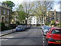
1
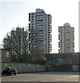
Wyndham Estate, Sultan Street
The style of these distinctive towers was used in several London County Council/Greater London Council estates (e.g. Image]) from 1962-64 when the Wyndham was built. It has five of these biggies.
Image: © Stephen Richards
Taken: 1 Apr 2012
0.10 miles
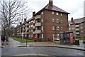
2
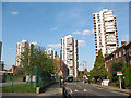
Tower blocks in Camberwell
These four tower blocks are, from left to right, Otterburn House, Crossmount House, Coniston House and Kevan House. There is a fifth in the group, Laird House, which is off the picture to the right. They are grouped around Wyndham Road (in the photo). The photo was taken from outside the entrance to St Michael's Academy which explains the traffic calming and the barriers on the pavement in the foreground.
Image: © Stephen Craven
Taken: 21 Apr 2010
0.10 miles
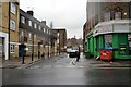
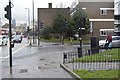
5
Urlwin Street
Picture taken looking toward Grosvenor Park
Image: © PAUL FARMER
Taken: 18 Apr 2009
0.11 miles
8
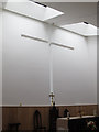
Interior of the new St Michael's church
The new church of St Michael and All Angels (Anglican) is part of the ARK All Saints Academy development It opened in February 2014 and replaces a former church further west on Wyndham Road. See Image for the outside view.
Image: © Stephen Craven
Taken: 11 Sep 2014
0.12 miles
9
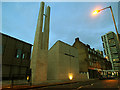
The new St Michael's church, Camberwell
The new church of St Michael and All Angels (Anglican) is part of the ARK All Saints Academy development Image It opened in February 2014 and replaces a former church further west on Wyndham Road Image which was on the site of the new school buildings.
Image: © Stephen Craven
Taken: 12 Feb 2014
0.12 miles
10

Camberwell, St. Michael and All Angels
Striking light brick Anglican church on Wyndham Road: http://www.southwark.anglican.org/parishes/056f
Image: © Mike Faherty
Taken: 24 Jun 2014
0.12 miles