IMAGES TAKEN NEAR TO
Urlwin Street, LONDON, SE5 0NG
Introduction
This page details the photographs taken nearby to Urlwin Street, SE5 0NG by members of the Geograph project.
The Geograph project started in 2005 with the aim of publishing, organising and preserving representative images for every square kilometre of Great Britain, Ireland and the Isle of Man.

There are currently over 7.5m images from over14,400 individuals and you can help contribute to the project by visiting https://www.geograph.org.uk
Image Map
Images are licensed for reuse under creativecommons.org/licenses/by-sa/2.0
Notes
- Clicking on the map will re-center to the selected point.
- The higher the marker number, the further away the image location is from the centre of the postcode.
Image Listing (132 Images Found)
Images are licensed for reuse under creativecommons.org/licenses/by-sa/2.0
Image
Details
Distance
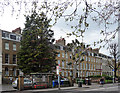
1
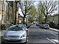
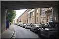
Urlwin Street
Surprisingly pretty conservation area of period housing.
Image: © PAUL FARMER
Taken: 18 Apr 2009
0.01 miles
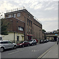
2
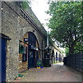
Businesses under railway arches off Grosvenor Terrace, Walworth, south London
Running through to Urlwin Street. A map of 1876 showed this to be the Herne Hill and City branch of the London, Chatham and Dover Railway. There was a Walworth Road station to the north (behind the camera).
Image: © Robin Stott
Taken: 27 Aug 2016
0.04 miles
3
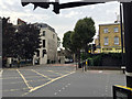
Junction of Camberwell Road and Urlwin Street, Walworth, south London
Urlwin Street is across the road, centre. Views at Image and Image Busy Albany Road B214 and glorious Burgess Park are behind the camera.
Image: © Robin Stott
Taken: 27 Aug 2016
0.05 miles
4
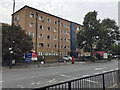
Hostel and flats, 56 and 58 Camberwell Road, Walworth, south London
The website of Walworth Methodist Church (Clubland) records that, following severe damage in World War II, "Her Majesty Queen Elizabeth the Queen Mother opened the new Clubland and Hostel on May 18th 1964". More recently, "We have gone into partnership with West London Mission and now the former Hostel has been converted to a 34 bed Hostel (for overseas students and asylum seekers) … West London Mission runs their Big Hour project in the remainder of the Hostel, with 10 flats for a rough sleepers initiative." http://www.walworthmethodist.org.uk The To Let sign relates to the building behind the tree, left.
Image: © Robin Stott
Taken: 27 Aug 2016
0.05 miles
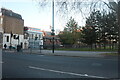
5
Burgess Park Camberwell Road entrance (A215)
Image: © Noel Foster
Taken: 10 Oct 2005
0.05 miles
6
Grosvenor Terrace, Walworth, south London
The view from beneath bridge 373 HHH.
Image: © Robin Stott
Taken: 27 Aug 2016
0.06 miles
7
Camberwell Road, Walworth
Burgess Park West is on the right.
Image: © David Howard
Taken: 27 Mar 2022
0.06 miles
8
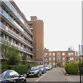
East side of Horsman House, Goschen Estate, Camberwell, south London
The view is north from the entry off Bethwin Road. At the time Southwark Council was announcing a £300 million major refurbishment of this and the Crawford Road estate. A railway viaduct out-of-shot right carries the busy Thameslink line and other services. Just visible to the right of the low block is the distinctive three-hole top of the Strata Tower at Elephant and Castle.
Image: © Robin Stott
Taken: 5 Apr 2016
0.06 miles
9
66-84 Camberwell Road
Another fine late Georgian terrace, similar to Image], a little further down opposite. Grade II listed.
Image: © Stephen Richards
Taken: 6 Apr 2012
0.06 miles
10
Clubland or the Walworth Methodist Church Theatre, Grosvenor Terrace, Walworth
Information about the church and its work is at http://www.walworthmethodist.org.uk
Image: © Robin Stott
Taken: 27 Aug 2016
0.06 miles