IMAGES TAKEN NEAR TO
Comber Grove, LONDON, SE5 0LA
Introduction
This page details the photographs taken nearby to Comber Grove, SE5 0LA by members of the Geograph project.
The Geograph project started in 2005 with the aim of publishing, organising and preserving representative images for every square kilometre of Great Britain, Ireland and the Isle of Man.

There are currently over 7.5m images from over14,400 individuals and you can help contribute to the project by visiting https://www.geograph.org.uk
Image Map
Images are licensed for reuse under creativecommons.org/licenses/by-sa/2.0
Notes
- Clicking on the map will re-center to the selected point.
- The higher the marker number, the further away the image location is from the centre of the postcode.
Image Listing (232 Images Found)
Images are licensed for reuse under creativecommons.org/licenses/by-sa/2.0
Image
Details
Distance
1
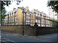
Camberwell: Comber Grove School, SE5
Since the School is shown on the Ordnance Survey map of 1896 but not on the 1882 edition, its date of origin can be placed at around 1890. A curious change of circumstances has come about here. When the school was built at that time it was a latecomer to an already well-established residential community of terraced houses. Now it is the survivor amongst a sea of much more modern buildings such as the adjacent Image The road in front is Comber Grove but the old Ordnance Survey maps show it as Leipzig Road, certainly up to 1938, so presumably the school was not originally called Comber Grove.
Image: © Nigel Cox
Taken: 11 Sep 2009
0.05 miles
3
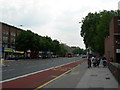
Camberwell Road, SE5
Near the junction with Bowyer Place.
Image: © Danny P Robinson
Taken: 7 Jun 2006
0.06 miles
4
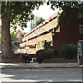
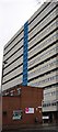
Bishopsmead, 236 Camberwell Road
Believed to date from the 1960s, the first and second floors of these flats are set back to allow an open south-facing balcony for all residents.
Image: © Robin Stott
Taken: 25 Aug 2013
0.07 miles
5
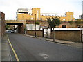
Camberwell: Medlar Street, SE5
The bridge carries the railway line between Loughborough Junction and Elephant and Castle stations over the road. Old Ordnance Survey maps show the road as being named Orchard Row, with the change to Medlar Street occurring between the 1896 and 1920 editions.
Image: © Nigel Cox
Taken: 11 Sep 2009
0.07 miles
6
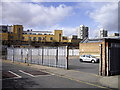
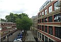
Car Park off Medlar Street
The tower blocks are Laird House (left) and Kevan House (right)
Image: © PAUL FARMER
Taken: 7 Mar 2009
0.08 miles
7
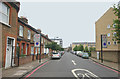
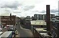
Medlar Street, London SE5
Looking towards the railway bridge from the junction with Camberwell New Road.
Image: © David Kemp
Taken: 19 Jul 2014
0.08 miles
8
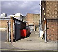
Service area off Medlar Street
These bins are used by shops in Camberwell Road
Image: © PAUL FARMER
Taken: 7 Mar 2009
0.08 miles
9
Medlar Street, Camberwell, South East London, SE5
Image: © JThomas
Taken: 25 Jul 2022
0.08 miles