IMAGES TAKEN NEAR TO
Badsworth Road, LONDON, SE5 0JY
Introduction
This page details the photographs taken nearby to Badsworth Road, SE5 0JY by members of the Geograph project.
The Geograph project started in 2005 with the aim of publishing, organising and preserving representative images for every square kilometre of Great Britain, Ireland and the Isle of Man.

There are currently over 7.5m images from over14,400 individuals and you can help contribute to the project by visiting https://www.geograph.org.uk
Image Map
Images are licensed for reuse under creativecommons.org/licenses/by-sa/2.0
Notes
- Clicking on the map will re-center to the selected point.
- The higher the marker number, the further away the image location is from the centre of the postcode.
Image Listing (235 Images Found)
Images are licensed for reuse under creativecommons.org/licenses/by-sa/2.0
Image
Details
Distance
1
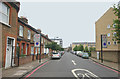
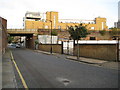
Medlar Street, London SE5
Looking towards the railway bridge from the junction with Camberwell New Road.
Image: © David Kemp
Taken: 19 Jul 2014
0.02 miles
2
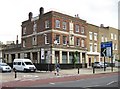
Camberwell: The King William IV, 283 Camberwell New Road, SE5
The pub dates from 1932 and was designed by the architect A E Sewell for the Truman's Brewery. It is made of brick with faience and inscribed tiling with text such as "Trumans Est'd 1666", "London Stout" and "Burton Ales".
For a monarch who only spent seven years on the throne King William IV seems, for some reason, to have had disproportionately more public houses named after him than any other king. A listing of old pubs in Camberwell alone reveals two others. Perhaps it was something to do with his relative popularity with the general public.
Image: © Nigel Cox
Taken: 11 Sep 2009
0.04 miles
4
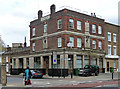
Former King William IV, Camberwell New Road
A typical pub of the former Truman Hanbury Buxton Brewery. Probably built some time between the wars and possibly designed by A.E. Sewell.
Apparently it closed in 2007.
Image: © Stephen Richards
Taken: 15 Apr 2012
0.05 miles
5
Camberwell: Medlar Street, SE5
The bridge carries the railway line between Loughborough Junction and Elephant and Castle stations over the road. Old Ordnance Survey maps show the road as being named Orchard Row, with the change to Medlar Street occurring between the 1896 and 1920 editions.
Image: © Nigel Cox
Taken: 11 Sep 2009
0.06 miles
6
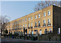
257-281 Camberwell New Road
A plain but dignified early-C19th stock brick terrace of two-bay houses in three storeys plus basement. The ground-floor windows are round-arched, and the first-floor windows have cast-iron balconies. Grade II listed.
Image: © Stephen Richards
Taken: 11 Mar 2012
0.06 miles
7
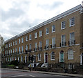
262-276 Camberwell New Road
A noble terrace, probably c1830, of two-bay, three storey houses over basements. Arched ground floor windows set in recessed arches, and first-floor wrought-iron balconies. The group is unified by the first-floor sillband, and cornice and blocking course at the top. Grade II listed.
The listing suggests some fronts have been rebuilt - the nearest two look likely candidates.
Image: © Stephen Richards
Taken: 21 Apr 2012
0.07 miles
8

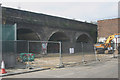
Camberwell, railway bridge
Carrying First Capital Connect services over Camberwell New Road.
Image: © Mike Faherty
Taken: 24 Jun 2014
0.07 miles
9
Site of former annexe to Walworth bus depot
An annexe to the bus depot stood on this site as recently as August 2015. For how it used to look see Image However, on my latest visit it had disappeared revealing the railway arches behind.
Image: © David Kemp
Taken: 5 Sep 2015
0.07 miles
10

Rear of Walworth bus garage
This is the frontage that abuts Medlar Street just east of the railway bridge. Behind the gates a blocked access to and from the garage can be seen. This saw little use in London Transport days but was used (probably as an exit) during the time (1990-97) the garage was operated by Londonlinks prior to its second period of closure. It was blocked off after 2004 by Travel London, the then owners of the garage, in order to allow the construction of an inspection pit just inside the building.
Image: © David Kemp
Taken: 19 Jul 2014
0.07 miles