IMAGES TAKEN NEAR TO
Cobourg Road, LONDON, SE5 0JB
Introduction
This page details the photographs taken nearby to Cobourg Road, SE5 0JB by members of the Geograph project.
The Geograph project started in 2005 with the aim of publishing, organising and preserving representative images for every square kilometre of Great Britain, Ireland and the Isle of Man.

There are currently over 7.5m images from over14,400 individuals and you can help contribute to the project by visiting https://www.geograph.org.uk
Image Map
Images are licensed for reuse under creativecommons.org/licenses/by-sa/2.0
Notes
- Clicking on the map will re-center to the selected point.
- The higher the marker number, the further away the image location is from the centre of the postcode.
Image Listing (189 Images Found)
Images are licensed for reuse under creativecommons.org/licenses/by-sa/2.0
Image
Details
Distance
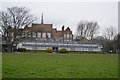
1
Loncroft Road, Peckham
Loncroft Road was originally called Longcroft Road. Only the eastern end of it remains, the rest having been swallowed up by Burgess Park in post-war redevelopment. See also Image taken only a few weeks earlier.
Image: © Stephen Craven
Taken: 14 Apr 2015
0.01 miles
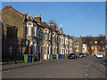
2

Terraced houses, Loncroft Road, Peckham
Variation in the bricks, ornamental details and strong modelling combine to make a richly-textured row of houses bordering Burgess Park. Detail: http://www.geograph.org.uk/photo/3898937
Image: © Robin Stott
Taken: 25 Aug 2013
0.02 miles
3
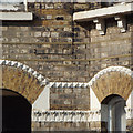
Brick detailing, terraced houses, Loncroft Road, Peckham
Part of this richly-textured terrace is seen in http://www.geograph.org.uk/p/3898925
Image: © Robin Stott
Taken: 25 Aug 2013
0.02 miles
6
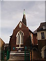
The New Peckham Mosque, Peckham
On Cobourg Road.
Was once the former Church of St Mark. Grade II listed.
See http://www.britishlistedbuildings.co.uk/en-470793-new-peckham-mosque-former-church-of-st-m for more details about the church.
Image: © David Anstiss
Taken: 25 Sep 2011
0.02 miles
7
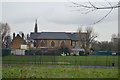
Christian building next to a mosque
The spire at the left of the photo is that of the former St Mark's church, now a mosque. But this pair of houses next to it has crosses on the outside so presumably belongs to a Christian group.
Image: © Stephen Craven
Taken: 14 Apr 2015
0.02 miles
8
New Peckham Mosque
Grade II listed. https://www.britishlistedbuildings.co.uk/101378492-new-peckham-mosque-former-church-of-st-mark-east-walworth-ward
Image: © N Chadwick
Taken: 3 Feb 2018
0.03 miles
9
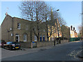
Houses on Cobourg Road
The spire behind the trees is that of the former St Mark's church, now a mosque.
Image: © Stephen Craven
Taken: 14 Apr 2015
0.03 miles
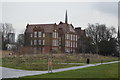
10
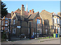
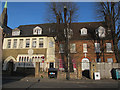
Old school house, Loncroft Road, Peckham
The house is within the grounds of Cobourg Road Primary School, and given its age it is probably the former schoolmaster's (or caretaker's) house.
Loncroft Road was originally called Longcroft Road.
Image: © Stephen Craven
Taken: 14 Apr 2015
0.03 miles