IMAGES TAKEN NEAR TO
Camberwell Road, LONDON, SE5 0HG
Introduction
This page details the photographs taken nearby to Camberwell Road, SE5 0HG by members of the Geograph project.
The Geograph project started in 2005 with the aim of publishing, organising and preserving representative images for every square kilometre of Great Britain, Ireland and the Isle of Man.

There are currently over 7.5m images from over14,400 individuals and you can help contribute to the project by visiting https://www.geograph.org.uk
Image Map
Images are licensed for reuse under creativecommons.org/licenses/by-sa/2.0
Notes
- Clicking on the map will re-center to the selected point.
- The higher the marker number, the further away the image location is from the centre of the postcode.
Image Listing (224 Images Found)
Images are licensed for reuse under creativecommons.org/licenses/by-sa/2.0
Image
Details
Distance
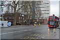
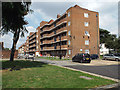
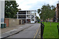
2
Kipling House and Marvell House, Camberwell
Looking north to blocks of former council flats, named after poets and believed to have been built in the 1950s. An OS map of the period shows a largely vacant site with Landor House, out of shot right, built, and some remaining shops on Camberwell Road. Kipling House, left, incorporates a parade of shops.
Note the low wall and rail: it robustly marks a boundary but does not exclude anyone visually or physically.
Image: © Robin Stott
Taken: 25 Aug 2013
0.02 miles
3
Marvell House, Camberwell
Looking northeast to blocks of former council flats, named after poets and believed to have been built in the 1950s. An OS map of the period shows a largely vacant site with Landor House, out of shot right, built, and some remaining shops on Camberwell Road. Kipling House, out of shot left, incorporates a parade of shops. Milton House in the distance.
Stephen Richards adds: built 1956 by the London County Council. Further information about municipal housing of the period would be very welcome.
Image: © Robin Stott
Taken: 25 Aug 2013
0.02 miles
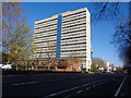
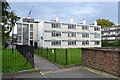
4
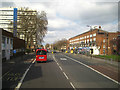
Sunday lunchtime, Camberwell Road, London
The slab block of flats on the left is Castlemead. The block of flats over shops on the right is Kipling House, from the 1950s.
Image: © Robin Stott
Taken: 5 Apr 2015
0.02 miles
5
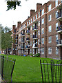
Rear of Marvell House flats, Camberwell
One of the post-war blocks in Camberwell named after poets.
Image: © Robin Stott
Taken: 18 Sep 2015
0.02 miles
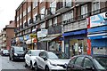
6
South end of Kipling House, Camberwell
Kipling House is a parade of shops with flats above facing Camberwell Road. Built in the early 1950s by London County Council, it replaced a number of small shops that may have suffered bomb damage. On the left, Castlemead. On the right, Marvell House Image Early evening.
Image: © Robin Stott
Taken: 18 Sep 2015
0.02 miles
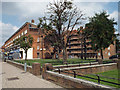
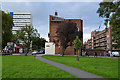
7
Empty Flecker House behind Broome Way, Camberwell
A block of 12 flats empty and locked. On the left is the end of the Broome Way flats Image On the right is the rear of post-war Marvell House flats.
Image: © Robin Stott
Taken: 18 Sep 2015
0.04 miles
8
Rear of empty Flecker House, off Broome Way, Camberwell
The reference is to James Elroy Flecker, 1884-1915, author of Hassan and "rich verse". This is one of the blocks of flats in Camberwell named after poets. On the right is the rear of the maisonettes at 30-72 Lomond Grove Image Multi-storey Masterman House pokes its head above the roofline.
Image: © Robin Stott
Taken: 18 Sep 2015
0.04 miles