IMAGES TAKEN NEAR TO
Meadows Way, LONDON, SE4 2FQ
Introduction
This page details the photographs taken nearby to Meadows Way, SE4 2FQ by members of the Geograph project.
The Geograph project started in 2005 with the aim of publishing, organising and preserving representative images for every square kilometre of Great Britain, Ireland and the Isle of Man.

There are currently over 7.5m images from over14,400 individuals and you can help contribute to the project by visiting https://www.geograph.org.uk
Image Map
Images are licensed for reuse under creativecommons.org/licenses/by-sa/2.0
Notes
- Clicking on the map will re-center to the selected point.
- The higher the marker number, the further away the image location is from the centre of the postcode.
Image Listing (95 Images Found)
Images are licensed for reuse under creativecommons.org/licenses/by-sa/2.0
Image
Details
Distance
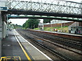
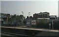
3
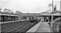
Brockley station, up platform
Two-car unit no 456009 calls at Brockley with a stopping service from London Victoria to London Bridge.
The spire in the distance is that of the pentecostal church Image
Image: © Stephen Craven
Taken: 10 Nov 2004
0.03 miles
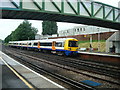
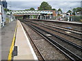
5
Brockley Station
View northward, towards London Bridge; ex-London, Brighton & South Coast Railway main line, London Bridge - Croydon etc. The train approaching on the Down Through line is Charing Cross - Tattenham Corner service. The overbridge in the distance carries the Nunhead - Lewisham Loop line. This station and others on the ex-LB&SC line were modernised in 2010 for the new London Overground services from Dalston to Crystal Palace and West Croydon.
Image: © Ben Brooksbank
Taken: 25 Mar 1962
0.04 miles
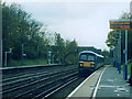
8
Brockley railway station, Greater London
Open in 1871 by the London Brighton & South Coast Railway on the line from London Bridge to Croydon.
View north towards New Cross Gate and London.
Image: © Nigel Thompson
Taken: 10 Aug 2010
0.05 miles
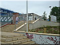
9
Brockley station
The buildings outside the station mark the line of Coulgate Street, which follows the line of the old Croydon Canal: much of the canal lies under the railway line that bought it up and superseded it, but the street line here marks a point at which the canal's course towards New Cross Gate diverges north-eastwards from the railway.
Image: © Christopher Hilton
Taken: 25 Jun 2013
0.05 miles
10
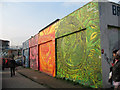
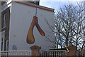
Mural on Coulgate Street, Brockley
This mural has been carefully painted with four colour themes. It is signed by the artist (Louis Henry) and dated 2004. For a closer view of one of the panels see Image
The woman at the far end (left of photo) was posing for a fashion shoot using the mural as a backdrop.
Image: © Stephen Craven
Taken: 29 Mar 2011
0.05 miles