IMAGES TAKEN NEAR TO
Foxwell Mews, LONDON, SE4 2EP
Introduction
This page details the photographs taken nearby to Foxwell Mews, SE4 2EP by members of the Geograph project.
The Geograph project started in 2005 with the aim of publishing, organising and preserving representative images for every square kilometre of Great Britain, Ireland and the Isle of Man.

There are currently over 7.5m images from over14,400 individuals and you can help contribute to the project by visiting https://www.geograph.org.uk
Image Map
Images are licensed for reuse under creativecommons.org/licenses/by-sa/2.0
Notes
- Clicking on the map will re-center to the selected point.
- The higher the marker number, the further away the image location is from the centre of the postcode.
Image Listing (117 Images Found)
Images are licensed for reuse under creativecommons.org/licenses/by-sa/2.0
Image
Details
Distance
1
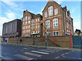
The John Stainer Primary School, and zebra crossing, Brockley
Image: © Ruth Sharville
Taken: 2 Jan 2023
0.05 miles
2
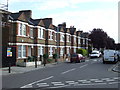
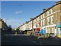
Revelon Road, Brockley
Revelon Road, a street of terraced housing in Brockley, South East London.
Image: © Malc McDonald
Taken: 29 Jun 2011
0.05 miles
3
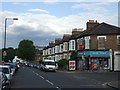
St. Asaph Road, Brockley
St. Asaph Road in Brockley, South East London.
Image: © Malc McDonald
Taken: 29 Jun 2011
0.06 miles
4
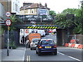
Mantle Road, Brockley
Mantle Road in Brockley. Here the road passes beneath a low railway bridge. Vehicles more than 8 feet 6 inches (or 2.6 metres) high are prohibited from passing under the bridge - although the marks on the warning markings suggest that plenty have tried.
Image: © Malc McDonald
Taken: 29 Jun 2011
0.07 miles
5
Railway bridge over Mantle Road, Brockley
Image: © Ruth Sharville
Taken: 2 Jan 2023
0.07 miles
8
Public convenience at Brockley Cross SE4
This modernised unisex facility is in the wall - indeed, is the wall - at Brockley station. As a limited concession to privacy, the architects (unknown) have retained separate "Gentlemen" and "Ladies" sections. It is hoped that this may become a resource for the development of local artistic/gymnastic talents, possibly as a demonstration event at the 2012 Olympics. That would however necessitate something on a grander scale, which may not be supportable by the area's drinking and transport infrastructure.
A site visitor adds: "Demolished March 2007!"
Image: © Philip Talmage
Taken: 26 Aug 2005
0.08 miles
9
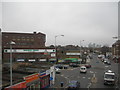
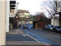
Brockley Cross SE4
Lots of roads converge here, and they funnel into a double mini roundabout. This is looking North, up Shardeloes Road, toward New Cross. The tall buildings on the horizon are Canary Wharf.
Image: © Danny P Robinson
Taken: 11 Apr 2006
0.08 miles
10
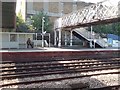
Platform 1, Brockley Station
From platform 2.
Image: © Rich Tea
Taken: 8 May 2008
0.09 miles