IMAGES TAKEN NEAR TO
Whitbread Road, LONDON, SE4 2BE
Introduction
This page details the photographs taken nearby to Whitbread Road, SE4 2BE by members of the Geograph project.
The Geograph project started in 2005 with the aim of publishing, organising and preserving representative images for every square kilometre of Great Britain, Ireland and the Isle of Man.

There are currently over 7.5m images from over14,400 individuals and you can help contribute to the project by visiting https://www.geograph.org.uk
Image Map
Images are licensed for reuse under creativecommons.org/licenses/by-sa/2.0
Notes
- Clicking on the map will re-center to the selected point.
- The higher the marker number, the further away the image location is from the centre of the postcode.
Image Listing (86 Images Found)
Images are licensed for reuse under creativecommons.org/licenses/by-sa/2.0
Image
Details
Distance
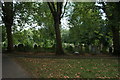
2
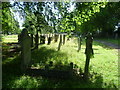
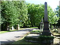
In Brockley Cemetery
Brockley Cemetery was opened as Deptford Cemetery in 1858, within a month of the adjoining Ladywell Cemetery to the east. The former was owned by the Borough of Deptford and the latter by the Borough of Lewisham. Until 1948, although the cemeteries were adjoining, they were physically separated by a wall. By that date the Victorian chapel of Brockley Cemetery had been destroyed by bombs, but the chapel in Ladywell Cemetery survived. The dividing wall between the cemeteries was removed in 1948 and this is today marked by a grassy ridge and a line of plane trees. A legacy of this is that while both cemeteries have a good network of paths, very few cross the old boundary. In 1965 when the London Borough of Lewisham took over both cemeteries, Deptford Cemetery was renamed Brockley Cemetery. The slightly grander monuments are in Brockley Cemetery, which is also more wooded. However, the overall interest is rather more local with numerous sailors buried here because of the nearness of Deptford Dockyard, along with such everyday Victorian inhabitants of the area as Alberta Codbolt, Horace Lermit and Philadelphia Sampson.
Image: © Marathon
Taken: 24 Aug 2011
0.09 miles
4
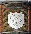
Ghost sign, Brockley
J. Chappell & Sons were funeral directors with an office conveniently over-looking Brockley Cemetery.
Image: © Jim Osley
Taken: 6 Nov 2014
0.09 miles
7
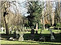
Entering Brockley Cemetery
Brockley Cemetery was opened as Deptford Cemetery in 1858, within a month of the adjoining Ladywell Cemetery to the east. The former was owned by the Borough of Deptford and the latter by the Borough of Lewisham. Until 1948, although the cemeteries were adjoining, they were physically separated by a wall. By that date the Victorian chapel of Brockley Cemetery had been destroyed by bombs, but the chapel in Ladywell Cemetery survived. The dividing wall between the cemeteries was removed in 1948 and this is today marked by a grassy ridge and a line of plane trees. A legacy of this is that while both cemeteries have a good network of paths, very few cross the old boundary. In 1965 when the London Borough of Lewisham took over both cemeteries, Deptford Cemetery was renamed Brockley Cemetery. The slightly grander monuments are in Brockley Cemetery, which is also more wooded. However, the overall interest is rather more local with numerous sailors buried here because of the nearness of Deptford Dockyard, along with such everyday Victorian inhabitants of the area as Alberta Codbolt, Horace Lermit and Philadelphia Sampson. This view is just as you come in through the main entrance on the corner of Brockley Road and Ivy Road.
Image: © Marathon
Taken: 24 Aug 2011
0.11 miles
8
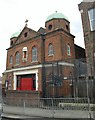
St Mary Magdalen's Church, Brockley
The church, with twin copper domes, was built in 1899 on Howson Road at the junction with Comerford Road.
Image: © Derek Harper
Taken: 11 Mar 2011
0.11 miles
10
View of gravestones in Ladywell & Brockley Cemetery #9
Looking south-southeast.
Image: © Robert Lamb
Taken: 19 Aug 2018
0.12 miles