IMAGES TAKEN NEAR TO
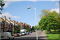
Montague Avenue, LONDON, SE4 1YP
Introduction
This page details the photographs taken nearby to Montague Avenue, SE4 1YP by members of the Geograph project.
The Geograph project started in 2005 with the aim of publishing, organising and preserving representative images for every square kilometre of Great Britain, Ireland and the Isle of Man.

There are currently over 7.5m images from over14,400 individuals and you can help contribute to the project by visiting https://www.geograph.org.uk
Image Map
Images are licensed for reuse under creativecommons.org/licenses/by-sa/2.0
Notes
- Clicking on the map will re-center to the selected point.
- The higher the marker number, the further away the image location is from the centre of the postcode.
Image Listing (86 Images Found)
Images are licensed for reuse under creativecommons.org/licenses/by-sa/2.0
Image
Details
Distance
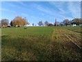
1
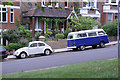
The beetle and the microbus
A pair of ancient Volkswagens spotted from Hilly Fields on Montague Avenue.
Image: © Chris Denny
Taken: 7 May 2011
0.01 miles
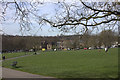
3
View over South London from Hilly Fields Park #2
Looking south-southwest.
Image: © Robert Lamb
Taken: 19 Aug 2018
0.04 miles
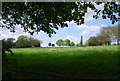
4
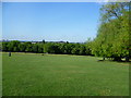
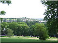
Hilly Fields
The summit of Hilly Fields stands 175 feet above sea level and gives extensive views across South London and towards Kent. In the second half of the 19th century, house building was proceeding rapidly in the area. Hilly Fields was saved from development by the protests of local residents. A committee of influential people was formed, which included Octavia Hill, the co-founder of the National Trust. She recorded that when visiting tenants in Deptford one day, she noticed a vase of freshly picked flowers, and on being told they had been picked on Hilly Fields, she set off to visit the area the same day. As a result she became instrumental in raising subscriptions to save Hilly Fields from being built over. The dedication of the park to the public took place in 1896.
Image: © Marathon
Taken: 31 May 2011
0.04 miles
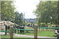
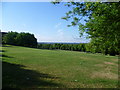
5
Hilly Fields, looking uphill!
This is the view from the bottom of the fields, just off Adelaide Avenue.
Image: © David Martin
Taken: 27 Nov 2011
0.06 miles
7
View from Hilly Fields
The summit of Hilly Fields stands 175 feet above sea level and gives extensive views across South London and towards Kent. In the second half of the 19th century, house building was proceeding rapidly in the area. Hilly Fields was saved from development by the protests of local residents. A committee of influential people was formed, which included Octavia Hill, the co-founder of the National Trust. She recorded that when visiting tenants in Deptford one day, she noticed a vase of freshly picked flowers, and on being told they had been picked on Hilly Fields, she set off to visit the area the same day. As a result she became instrumental in raising subscriptions to save Hilly Fields from being built over. The dedication of the park to the public took place in 1896.
Image: © Marathon
Taken: 31 May 2011
0.07 miles
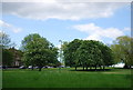
10
Hilly Fields, Brockley
A view southwards over Hilly Fields, a green open spece in Brockley, South East London. The parkland on the left in the distance is Blythe Hill Fields. See Image for an image taken from Blythe Hill Fields looking back towards Hilly Fields.
Image: © Malc McDonald
Taken: 29 Jun 2011
0.09 miles