IMAGES TAKEN NEAR TO
Upper Brockley Road, LONDON, SE4 1SY
Introduction
This page details the photographs taken nearby to Upper Brockley Road, SE4 1SY by members of the Geograph project.
The Geograph project started in 2005 with the aim of publishing, organising and preserving representative images for every square kilometre of Great Britain, Ireland and the Isle of Man.

There are currently over 7.5m images from over14,400 individuals and you can help contribute to the project by visiting https://www.geograph.org.uk
Image Map (Loading...)


Getting Data...Please wait
Leaflet Map data © OpenStreetMap
Images are licensed for reuse under creativecommons.org/licenses/by-sa/2.0
Notes
- Clicking on the map will re-center to the selected point.
- The higher the marker number, the further away the image location is from the centre of the postcode.
Image Listing (40 Images Found)
Images are licensed for reuse under creativecommons.org/licenses/by-sa/2.0
Image
Details
Distance
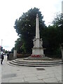
2
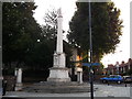
Lewisham War Memorial
On the junction of the A20 Lewisham Way (in front) and Upper Brockley Road (on the right).
Image: © David Anstiss
Taken: 25 Sep 2011
0.11 miles
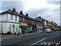
3
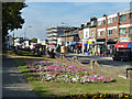
Lewisham Way (A20)
The flowerbed is in a sort of long narrow park between the main road and a parallel one-sided residential road, also called Lewisham Way.
Image: © Robin Webster
Taken: 1 Oct 2011
0.12 miles
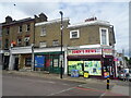
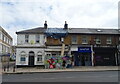
9
The changing retail scene, SE14
Halal Meat Centre beside a former branch of Home and Colonial Stores.
Image: © Robin Webster
Taken: 1 Oct 2011
0.14 miles