IMAGES TAKEN NEAR TO
Manwood Road, LONDON, SE4 1SA
Introduction
This page details the photographs taken nearby to Manwood Road, SE4 1SA by members of the Geograph project.
The Geograph project started in 2005 with the aim of publishing, organising and preserving representative images for every square kilometre of Great Britain, Ireland and the Isle of Man.

There are currently over 7.5m images from over14,400 individuals and you can help contribute to the project by visiting https://www.geograph.org.uk
Image Map
Images are licensed for reuse under creativecommons.org/licenses/by-sa/2.0
Notes
- Clicking on the map will re-center to the selected point.
- The higher the marker number, the further away the image location is from the centre of the postcode.
Image Listing (59 Images Found)
Images are licensed for reuse under creativecommons.org/licenses/by-sa/2.0
Image
Details
Distance
1
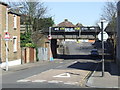
Low bridge, Bexhill Road, SE4
The bridge carries a railway line over Bexhill Road. Although the road dips down to pass beneath the bridge, there is limited clearance meaning that some vehicles (such as double-deck buses) will be too high to pass underneath. The triangular sign on the lamp post warns drivers of the height restrictionge ahead. The circular sign then prohibits any vehicle higher than 11 feet 9 inches from passing.
Image: © Malc McDonald
Taken: 19 Mar 2011
0.06 miles
2
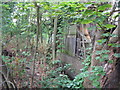
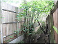
The River Ravensbourne - Honor Oak Branch, west of Foxborough Gardens, SE4
Image: © Mike Quinn
Taken: 5 Aug 2009
0.08 miles
3
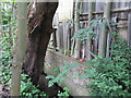
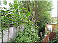
The River Ravensbourne - Honor Oak Branch, west of Foxborough Gardens, SE4 (2)
There was water here, even in August (2009).
Image: © Mike Quinn
Taken: 5 Aug 2009
0.09 miles
4
The River Ravensbourne - Honor Oak Branch, west of Foxborough Gardens, SE4 (3)
Image: © Mike Quinn
Taken: 5 Aug 2009
0.10 miles
6
The River Ravensbourne - Honor Oak Branch, east of Foxborough Gardens, SE4
Image: © Mike Quinn
Taken: 5 Aug 2009
0.11 miles
7
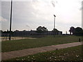
Prendergast Ladywell Fields College
Prendergast Ladywell Fields College was formerly the Crofton School.
Seen from Ewhurst Road entrance.
The school is alongside an open space which slopes down to the Ravensbourne River. In the foreground is a sports field.
Image: © David Anstiss
Taken: 25 Sep 2011
0.12 miles
9
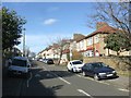
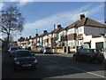
Chudleigh Road at the junction with Henryson Road
Image: © David Martin
Taken: 24 Apr 2015
0.15 miles