IMAGES TAKEN NEAR TO
Ray Bell Court, Wickham Mews, LONDON, SE4 1PS
Introduction
This page details the photographs taken nearby to Ray Bell Court, Wickham Mews, SE4 1PS by members of the Geograph project.
The Geograph project started in 2005 with the aim of publishing, organising and preserving representative images for every square kilometre of Great Britain, Ireland and the Isle of Man.

There are currently over 7.5m images from over14,400 individuals and you can help contribute to the project by visiting https://www.geograph.org.uk
Image Map
Images are licensed for reuse under creativecommons.org/licenses/by-sa/2.0
Notes
- Clicking on the map will re-center to the selected point.
- The higher the marker number, the further away the image location is from the centre of the postcode.
Image Listing (52 Images Found)
Images are licensed for reuse under creativecommons.org/licenses/by-sa/2.0
Image
Details
Distance
1
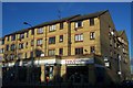
Albertines, SE8
On Lewisham Way at the corner of Friendly Street.
Image: © Robin Webster
Taken: 1 Oct 2011
0.07 miles
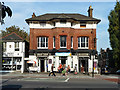
2
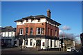
Bank Buildings, Lewisham Way
No longer a bank.
Image: © Robin Webster
Taken: 1 Oct 2011
0.07 miles
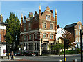
3
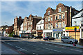
A remarkable row, Lewisham Way, SE8
An unusual alternation of styles, which must have been deliberate. The far, tall building was built around 1886 as a bank. The row as a whole seems older, as it is shown on maps of 1873. Apart from the far building, the row is not nationally listed.
Image: © Robin Webster
Taken: 1 Oct 2011
0.07 miles
4
Albertine's Public House, St John's
On the junction of (237) Lewisham Way (in front) and Friendly Street (on the right).
Image: © David Anstiss
Taken: 27 Nov 2009
0.08 miles
6
Tesco Express St. John's
On the junction of Lewisham Way (in front) and Oscar Street (on the right).
Image: © David Anstiss
Taken: 27 Nov 2009
0.09 miles
7
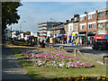
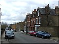
Lewisham Way (A20)
The flowerbed is in a sort of long narrow park between the main road and a parallel one-sided residential road, also called Lewisham Way.
Image: © Robin Webster
Taken: 1 Oct 2011
0.11 miles
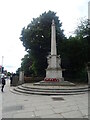
8
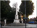
Lewisham War Memorial
On the junction of the A20 Lewisham Way (in front) and Upper Brockley Road (on the right).
Image: © David Anstiss
Taken: 25 Sep 2011
0.12 miles