IMAGES TAKEN NEAR TO
Harefield Mews, LONDON, SE4 1LP
Introduction
This page details the photographs taken nearby to Harefield Mews, SE4 1LP by members of the Geograph project.
The Geograph project started in 2005 with the aim of publishing, organising and preserving representative images for every square kilometre of Great Britain, Ireland and the Isle of Man.

There are currently over 7.5m images from over14,400 individuals and you can help contribute to the project by visiting https://www.geograph.org.uk
Image Map
Images are licensed for reuse under creativecommons.org/licenses/by-sa/2.0
Notes
- Clicking on the map will re-center to the selected point.
- The higher the marker number, the further away the image location is from the centre of the postcode.
Image Listing (95 Images Found)
Images are licensed for reuse under creativecommons.org/licenses/by-sa/2.0
Image
Details
Distance
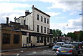
6
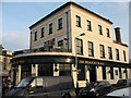
The Brockley Barge
A Wetherspoon pub on the corner of Brockley Road and Foxberry Road (foreground).
Image: © Stephen Craven
Taken: 29 Mar 2011
0.04 miles
9
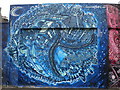
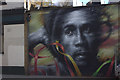
Brockley Station Mural, Coulgate Street SE4
Artwork by Louis Henry (2004) - Commissioned by Brokley Cross Action Group.
Image: © Robin Sones
Taken: 25 Jul 2010
0.05 miles