IMAGES TAKEN NEAR TO
Adelaide Avenue, LONDON, SE4 1LE
Introduction
This page details the photographs taken nearby to Adelaide Avenue, SE4 1LE by members of the Geograph project.
The Geograph project started in 2005 with the aim of publishing, organising and preserving representative images for every square kilometre of Great Britain, Ireland and the Isle of Man.

There are currently over 7.5m images from over14,400 individuals and you can help contribute to the project by visiting https://www.geograph.org.uk
Image Map
Images are licensed for reuse under creativecommons.org/licenses/by-sa/2.0
Notes
- Clicking on the map will re-center to the selected point.
- The higher the marker number, the further away the image location is from the centre of the postcode.
Image Listing (86 Images Found)
Images are licensed for reuse under creativecommons.org/licenses/by-sa/2.0
Image
Details
Distance
3
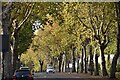
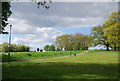
Adelaide Avenue at Hilly Fields
A true avenue, with fine rows of trees on each side.
Image: © David Martin
Taken: 29 Oct 2022
0.03 miles
4
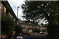
View along Ivy Road
Looking south-southeast.
Image: © Robert Lamb
Taken: 19 Aug 2018
0.04 miles

7
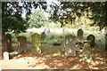
View of gravestones in Ladywell & Brockley Cemetery
Looking north-northeast.
Image: © Robert Lamb
Taken: 19 Aug 2018
0.06 miles
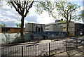
8
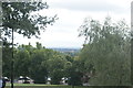
View over South London from Hilly Fields Park #3
Looking south-southwest.
Image: © Robert Lamb
Taken: 19 Aug 2018
0.07 miles
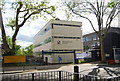
9
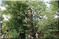
View of a chimney at the back of the Ladywell & Brockley Cemetery
Looking north-northeast.
Image: © Robert Lamb
Taken: 19 Aug 2018
0.07 miles
10
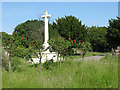
War memorial, Ladywell Cemetery
This memorial does not have any names carved into it. Rather it commemorates in general the fallen of World War 1.
Image: © Stephen Craven
Taken: 8 Jun 2008
0.07 miles