IMAGES TAKEN NEAR TO
Francemary Road, LONDON, SE4 1JS
Introduction
This page details the photographs taken nearby to Francemary Road, SE4 1JS by members of the Geograph project.
The Geograph project started in 2005 with the aim of publishing, organising and preserving representative images for every square kilometre of Great Britain, Ireland and the Isle of Man.

There are currently over 7.5m images from over14,400 individuals and you can help contribute to the project by visiting https://www.geograph.org.uk
Image Map
Images are licensed for reuse under creativecommons.org/licenses/by-sa/2.0
Notes
- Clicking on the map will re-center to the selected point.
- The higher the marker number, the further away the image location is from the centre of the postcode.
Image Listing (88 Images Found)
Images are licensed for reuse under creativecommons.org/licenses/by-sa/2.0
Image
Details
Distance
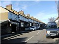
3
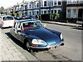
Classic 1974 Citroen DS, Chudleigh Road, Ladywell
Image: © Chris Whippet
Taken: 1 Mar 2015
0.08 miles
4

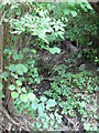
The River Ravensbourne - Honor Oak Branch, near Slagrove Place, SE13 (5)
Image: © Mike Quinn
Taken: 5 Aug 2009
0.09 miles
5
The River Ravensbourne - Honor Oak Branch, near Slagrove Place, SE13 (4)
Image: © Mike Quinn
Taken: 5 Aug 2009
0.09 miles
6
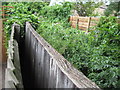
The River Ravensbourne - Honor Oak Branch, near Slagrove Place, SE13
Image: © Mike Quinn
Taken: 5 Aug 2009
0.09 miles
7
The River Ravensbourne - Honor Oak Branch, near Slagrove Place, SE13 (2)
Image: © Mike Quinn
Taken: 5 Aug 2009
0.09 miles
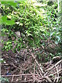
9
The River Ravensbourne - Honor Oak Branch, near Slagrove Place, SE13 (3)
Image: © Mike Quinn
Taken: 5 Aug 2009
0.10 miles