IMAGES TAKEN NEAR TO
Gordonbrock Road, LONDON, SE4 1JB
Introduction
This page details the photographs taken nearby to Gordonbrock Road, SE4 1JB by members of the Geograph project.
The Geograph project started in 2005 with the aim of publishing, organising and preserving representative images for every square kilometre of Great Britain, Ireland and the Isle of Man.

There are currently over 7.5m images from over14,400 individuals and you can help contribute to the project by visiting https://www.geograph.org.uk
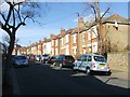
Image Map
Images are licensed for reuse under creativecommons.org/licenses/by-sa/2.0
Notes
- Clicking on the map will re-center to the selected point.
- The higher the marker number, the further away the image location is from the centre of the postcode.
Image Listing (67 Images Found)
Images are licensed for reuse under creativecommons.org/licenses/by-sa/2.0
Image
Details
Distance
4
(Part of) the Ladywell Water Tower, Dressington Avenue, SE4
Image: © Mike Quinn
Taken: 5 Aug 2009
0.09 miles
5
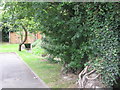
The River Ravensbourne - Honor Oak Branch, west of Dressington Avenue, SE4
Image: © Mike Quinn
Taken: 5 Aug 2009
0.09 miles
6
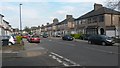
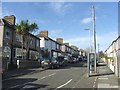
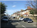
Chudleigh Road at the junction with Henryson Road
Image: © David Martin
Taken: 24 Apr 2015
0.09 miles
8
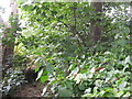
The River Ravensbourne - Honor Oak Branch, east of Dressington Avenue, SE4
Image: © Mike Quinn
Taken: 5 Aug 2009
0.10 miles
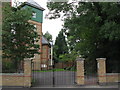
10
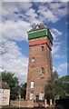
The workhouse water tower
The former water tower of the Bermondsey Institution, opened by the then Prince of Wales in 1900 as an infirmary for the elderly. It has now been converted into flats and remains a prominent landmark in the area.
Image: © Chris Denny
Taken: 8 May 2011
0.11 miles