IMAGES TAKEN NEAR TO
Foxborough Gardens, LONDON, SE4 1HT
Introduction
This page details the photographs taken nearby to Foxborough Gardens, SE4 1HT by members of the Geograph project.
The Geograph project started in 2005 with the aim of publishing, organising and preserving representative images for every square kilometre of Great Britain, Ireland and the Isle of Man.

There are currently over 7.5m images from over14,400 individuals and you can help contribute to the project by visiting https://www.geograph.org.uk
Image Map (Loading...)


Getting Data...Please wait
Leaflet Map data © OpenStreetMap
Images are licensed for reuse under creativecommons.org/licenses/by-sa/2.0
Notes
- Clicking on the map will re-center to the selected point.
- The higher the marker number, the further away the image location is from the centre of the postcode.
Image Listing (113 Images Found)
Images are licensed for reuse under creativecommons.org/licenses/by-sa/2.0
Image
Details
Distance
1
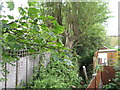
The River Ravensbourne - Honor Oak Branch, east of Foxborough Gardens, SE4
Image: © Mike Quinn
Taken: 5 Aug 2009
0.10 miles
2
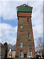
The workhouse water tower
The former water tower of the Bermondsey Institution, opened by the then Prince of Wales in 1900 as an infirmary for the elderly. It has now been converted into flats and remains a prominent landmark in the area.
Image: © Chris Denny
Taken: 8 May 2011
0.10 miles
3
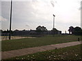
Prendergast Ladywell Fields College
Prendergast Ladywell Fields College was formerly the Crofton School.
Seen from Ewhurst Road entrance.
The school is alongside an open space which slopes down to the Ravensbourne River. In the foreground is a sports field.
Image: © David Anstiss
Taken: 25 Sep 2011
0.10 miles
4
The River Ravensbourne - Honor Oak Branch, west of Foxborough Gardens, SE4 (3)
Image: © Mike Quinn
Taken: 5 Aug 2009
0.11 miles
5
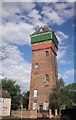
Ladywell Water Tower
Seen across Dressington Avenue. Image gives the listed building description http://www.britishlistedbuildings.co.uk/en-203479-the-ladywell-water-tower-lewisham . Now surrounded by new housing.
Image: © Derek Harper
Taken: 11 Mar 2011
0.11 miles
6
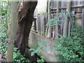
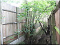
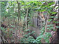
The River Ravensbourne - Honor Oak Branch, west of Foxborough Gardens, SE4 (2)
There was water here, even in August (2009).
Image: © Mike Quinn
Taken: 5 Aug 2009
0.11 miles
7
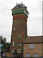
The Ladywell Water Tower, Dressington Avenue, SE4
The tower is a Grade II listed building: "Water tower. 1898-1900 by Ernest Newman, the founder of the Art Workers Guild. It was the water tower to St Olave's Union, built to house the aged and infirm which was a new development from the workhouses. Built of yellow brick in Flemish bond with red brick dressings and lacing courses. 120 feet high battered square tower of 5 storeys on plinth with moulded stone band. 1 cambered window opening to each floor. Moulded stone and brick cornice with huge green painted cast iron water tank with 3 x 5 panels to front. Hipped slate roof with gabled dormer with semi-circular opening and keystone. Ornamental cast iron balustrading to water tower with corner finials with spiked balls. The water tower had a well 120 feet deep from which water was drawn to supply the laundry and local houses. Most of St Olave's Union has since been demolished with the exception of the water tower and the central hospital unit." - see http://www.britishlistedbuildings.co.uk/en-203479-the-ladywell-water-tower-lewisham.
Image: © Mike Quinn
Taken: 5 Aug 2009
0.11 miles
8
(Part of) the Ladywell Water Tower, Dressington Avenue, SE4
Image: © Mike Quinn
Taken: 5 Aug 2009
0.11 miles
9
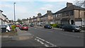
Chudleigh Road at the junction with Henryson Road
Image: © David Martin
Taken: 24 Apr 2015
0.11 miles
10
The River Ravensbourne - Honor Oak Branch, west of Foxborough Gardens, SE4
Image: © Mike Quinn
Taken: 5 Aug 2009
0.11 miles