IMAGES TAKEN NEAR TO
Nelson Mandela Road, LONDON, SE3 9QS
Introduction
This page details the photographs taken nearby to Nelson Mandela Road, SE3 9QS by members of the Geograph project.
The Geograph project started in 2005 with the aim of publishing, organising and preserving representative images for every square kilometre of Great Britain, Ireland and the Isle of Man.

There are currently over 7.5m images from over14,400 individuals and you can help contribute to the project by visiting https://www.geograph.org.uk
Image Map
Images are licensed for reuse under creativecommons.org/licenses/by-sa/2.0
Notes
- Clicking on the map will re-center to the selected point.
- The higher the marker number, the further away the image location is from the centre of the postcode.
Image Listing (81 Images Found)
Images are licensed for reuse under creativecommons.org/licenses/by-sa/2.0
Image
Details
Distance
1
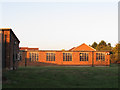
Remains of RAF Kidbrooke
During and after the second world war there was an extensive RAF base at Kidbrooke (though it seems from online research that it was a training and administrative centre rather than an airfield). Most of the site is now housing or parks, but a few old blocks remain here: their present use is unclear.
Image: © Stephen Craven
Taken: 2 Oct 2011
0.06 miles
2

Heating pipes?
These large diameter pipes look as though they may be part of the Kidbrooke district heating scheme. The building is part of the former RAF site: see also Image
Image: © Stephen Craven
Taken: 2 Oct 2011
0.07 miles
3

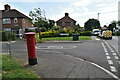
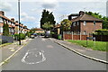
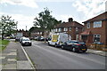
Nelson Mandela Way
Housing blocks on a small estate in Kidbrooke, one of many places in London named after the South African hero.
Image: © Stephen Craven
Taken: 2 Oct 2011
0.07 miles
7

Footpath alongside the A2
Most of the way through south-east London, the dual carriageway A2 has a cycle/footpath running adjacent to it, but usually up above a cutting or down below elevated sections of the road, so that drivers would not know it is there.
Image: © Stephen Craven
Taken: 2 Oct 2011
0.11 miles
8
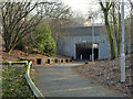
Subway under the A2
The white backed inscription on the bridge is its number: A2/11.50/0.
Image: © Robin Webster
Taken: 4 Feb 2012
0.11 miles
9
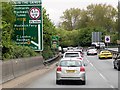
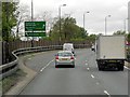
A2 Approaching Sun-in-the-Sands Junction
The northbound A2 approaching Sun in the Sands roundabout.
Image: © David Dixon
Taken: 15 May 2013
0.12 miles