IMAGES TAKEN NEAR TO
Tizzard Grove, LONDON, SE3 9DH
Introduction
This page details the photographs taken nearby to Tizzard Grove, SE3 9DH by members of the Geograph project.
The Geograph project started in 2005 with the aim of publishing, organising and preserving representative images for every square kilometre of Great Britain, Ireland and the Isle of Man.

There are currently over 7.5m images from over14,400 individuals and you can help contribute to the project by visiting https://www.geograph.org.uk
Image Map
Images are licensed for reuse under creativecommons.org/licenses/by-sa/2.0
Notes
- Clicking on the map will re-center to the selected point.
- The higher the marker number, the further away the image location is from the centre of the postcode.
Image Listing (110 Images Found)
Images are licensed for reuse under creativecommons.org/licenses/by-sa/2.0
Image
Details
Distance
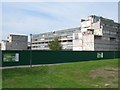
3
Pinto Way Housing Blocks
These post-war housing blocks (part of the Ferrier Estate) are soon to be demolished as part of the re-generation of the area.
Berkeley Homes are building the new homes.
Image: © David Anstiss
Taken: 11 Sep 2011
0.03 miles
4
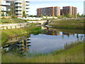
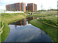
Lake in Cator Park at Kidbrooke Village
This lake is part of the new Kidbrooke Village development on the site of the former Ferrier Estate. The park here has been named Cator Park after the nearby Cator Estate at Blackheath Park but this is a little confusing as there is also a Cator Park at Beckenham - see http://www.geograph.org.uk/photo/2404836
Clearly the developers preferred the name of the park to be linked to the very much upmarket Blackheath Park, rather than what was here before.
Image: © Marathon
Taken: 16 Aug 2014
0.05 miles
5
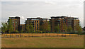
Kidbrooke Village, new developments
Three new blocks of housing on the redeveloped estate.
Image: © Stephen Craven
Taken: 5 Aug 2014
0.05 miles
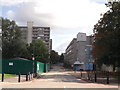
6
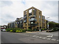
New housing in Kidbrooke
New housing in Kidbrooke, in the suburbs of south east London.
Image: © Malc McDonald
Taken: 14 Jul 2019
0.06 miles
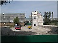
7
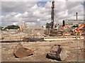
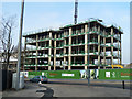
Kidbrooke Regeneration begins
New housing construction is started on Weigall Road.
In the background more blocks of the Ferrier Estate have yet to be demolished.
In the foreground, a piling machine and ringbeams (foundations) for the new buildings.
Image: © David Anstiss
Taken: 11 Sep 2011
0.07 miles
9
Cator Park at Kidbrooke Village
This lake is part of the new Kidbrooke Village development on the site of the former Ferrier Estate. The park here has been named Cator Park after the nearby Cator Estate at Blackheath Park but this is a little confusing as there is also a Cator Park at Beckenham - see http://www.geograph.org.uk/photo/2404836
Clearly the developers preferred the name of the park to be linked to the very much upmarket Blackheath Park, rather than what was here before. It all looks very new and tidy at the moment.
Image: © Marathon
Taken: 16 Aug 2014
0.08 miles
10
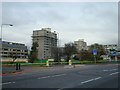
Wallace Court under construction
The 1960s concept of urban high density housing on this site is being replaced with the 2010s approach.
Image: © Robin Webster
Taken: 4 Feb 2012
0.08 miles