IMAGES TAKEN NEAR TO
Lee Road, LONDON, SE3 9DA
Introduction
This page details the photographs taken nearby to Lee Road, SE3 9DA by members of the Geograph project.
The Geograph project started in 2005 with the aim of publishing, organising and preserving representative images for every square kilometre of Great Britain, Ireland and the Isle of Man.

There are currently over 7.5m images from over14,400 individuals and you can help contribute to the project by visiting https://www.geograph.org.uk
Image Map (Loading...)


Getting Data...Please wait
Leaflet Map data © OpenStreetMap
Images are licensed for reuse under creativecommons.org/licenses/by-sa/2.0
Notes
- Clicking on the map will re-center to the selected point.
- The higher the marker number, the further away the image location is from the centre of the postcode.
Image Listing (68 Images Found)
Images are licensed for reuse under creativecommons.org/licenses/by-sa/2.0
Image
Details
Distance
1
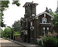
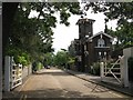
Former lodge to the Cator Estate, Manor Way, SE3
Image: © Mike Quinn
Taken: 2 Sep 2010
0.07 miles
2
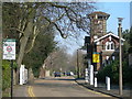
Manor Way, SE3
This is a private road onto the Cator Estate. Picture taken at the junction of Lee Road.
Image: © Danny P Robinson
Taken: 25 Mar 2007
0.10 miles
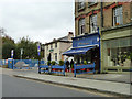
4
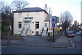
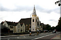
Lee Green Constitutional Club
On the junction of B212 Lee Road (in front) and Meadowcourt Road (on the left).
Image: © David Anstiss
Taken: 27 Nov 2009
0.14 miles
5
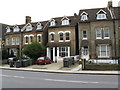
364 Lee High Road, Lewisham
Lee High Road runs from Lewisham Town Centre southeastwards to Lee Green, about a mile away. Many large houses like this one, No 364 with the red car in front of it, were built along here. Originally they would have been in single ownership, but now almost all have been subdivided into flats. The example shown here appears to be in excellent condition. Note the removal of the front garden to provide car-parking space.
Image: © Dr Neil Clifton
Taken: 12 Mar 2009
0.15 miles
6
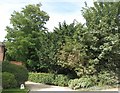
(The line of) Kid Brook
The line of tall trees marks the course of Middle Kid Brook west of Parkgate, SE3 - see the satellite image http://wtp2.appspot.com/wheresthepath.htm?lat=51.4607896766516&lon=0.012937957789207796&gz=20&oz=10>=1.
Image: © Mike Quinn
Taken: 2 Sep 2010
0.15 miles
7
Villa Moura, Lee Road, SE3
Lee Green Constitutional Club is beyond, but appears to be undergoing some sort of conversion.
Image: © Robin Webster
Taken: 30 Oct 2011
0.17 miles
8
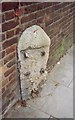
Old Milestone by the A20, Lee High Road
Stone post (plates lost) by the A20, in parish of Lee (LEWISHAM District), Lee High Road, West of junction with Lenham Road, against brick wall in pavement, on South side of road. New Cross marker, erected by the New Cross turnpike trust in the 19th century.
Inscription once read:-
: (6 / MILES / TO / LONDON / BRIDGE) : : (6 / MILES / TO / FOOTSCRAY) :
Milestone Society National ID: KE_LF06.
Image: © C Woodward
Taken: 23 Jan 2007
0.17 miles
9
New Testament Church of God, Lee High Road
Image: © Dr Neil Clifton
Taken: 15 Sep 2008
0.17 miles
10
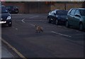
Urban Fox on Meadowcourt Road
Had wandered down this road to photograph the church. But the church has gone replaced by a private house. A car passed me and then I spotted this fox wander between the two parked cars on the right. It stayed in the road for several minutes. I saw my chance and took a photo. It looked at me but didn't move. Then I moved and it wandered across the road to hunt for food.
Image: © David Anstiss
Taken: 27 Nov 2009
0.18 miles