IMAGES TAKEN NEAR TO
Hervey Road, LONDON, SE3 8BS
Introduction
This page details the photographs taken nearby to Hervey Road, SE3 8BS by members of the Geograph project.
The Geograph project started in 2005 with the aim of publishing, organising and preserving representative images for every square kilometre of Great Britain, Ireland and the Isle of Man.

There are currently over 7.5m images from over14,400 individuals and you can help contribute to the project by visiting https://www.geograph.org.uk
Image Map
Images are licensed for reuse under creativecommons.org/licenses/by-sa/2.0
Notes
- Clicking on the map will re-center to the selected point.
- The higher the marker number, the further away the image location is from the centre of the postcode.
Image Listing (87 Images Found)
Images are licensed for reuse under creativecommons.org/licenses/by-sa/2.0
Image
Details
Distance
1
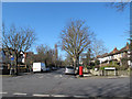
Junction of Hervey Road and Eastbrook Road
The postbox is seen in a closer view in Image
Image: © Stephen Craven
Taken: 27 Feb 2015
0.04 miles
2
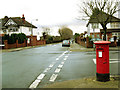
Postbox on Eastbrook Road
A standard EIIR box on the corner of Hervey Road.
Image: © Stephen Craven
Taken: 25 Dec 2012
0.05 miles
3
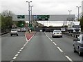
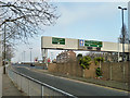
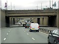
A2, Sun-in-the-Sands Junction
The Sun in the Sands interchange was built in the late 1960's for the A2 and the A102(M), it was to be a part of the London Ringway system. The A2 branches to the left, Shooters Hill whilst the road ahead continues , under the roundabout, as the A102 (previously A102M).
Since 1981, the roundabout has been used as part of the London Marathon. The junction is part of the green route of the Marathon. This is the route that the elite runners use so it is one of most viewed interchanges seen in the race as it is quite early on the route. On race day it is closed until the last runner passes by (http://www.sabre-roads.org.uk/wiki/index.php?title=Sun_in_the_Sands SABRE Wiki).
Image: © David Dixon
Taken: 15 May 2013
0.05 miles
4
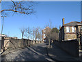
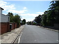
Dead end of Hervey Road
Where Hervey Road was cut off by the A2 trunk road it now bends round to a dead end.
Image: © Stephen Craven
Taken: 27 Feb 2015
0.05 miles
6
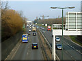
A2 and A107 part company
The A2 reverts to its earlier course towards central London, and the main route continues as the A107 to the Blackwall Tunnel and beyond.
Image: © Robin Webster
Taken: 4 Feb 2012
0.06 miles
7
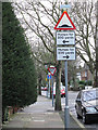
Road signs galore
These signs on Hervey Road warn motorists of speed humps, a give way junction and a dead-end street beyond.
Image: © Stephen Craven
Taken: 25 Dec 2012
0.06 miles
9
Sun-in-the Sands Junction, A102
The Sun in the Sands interchange was built in the late 1960's for the A2 and the A102(M), it was to be a part of the London Ringway system. The A2 branches to the left, Shooters Hill whilst the road ahead continues, under the roundabout, as the A102 (previously A102M).
Image: © David Dixon
Taken: 15 May 2013
0.11 miles
10
A2 with Routemaster
Hurrying south is preserved Routemaster RM 1799, owned by Ensignbus of Purfleet. It has probably come through the Blackwall Tunnel.
Image: © Robin Webster
Taken: 4 Feb 2012
0.13 miles