IMAGES TAKEN NEAR TO
Maze Hill, LONDON, SE3 7UD
Introduction
This page details the photographs taken nearby to Maze Hill, SE3 7UD by members of the Geograph project.
The Geograph project started in 2005 with the aim of publishing, organising and preserving representative images for every square kilometre of Great Britain, Ireland and the Isle of Man.

There are currently over 7.5m images from over14,400 individuals and you can help contribute to the project by visiting https://www.geograph.org.uk
Image Map
Images are licensed for reuse under creativecommons.org/licenses/by-sa/2.0
Notes
- Clicking on the map will re-center to the selected point.
- The higher the marker number, the further away the image location is from the centre of the postcode.
Image Listing (140 Images Found)
Images are licensed for reuse under creativecommons.org/licenses/by-sa/2.0
Image
Details
Distance
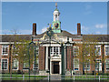
1
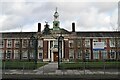
John Roan School
Grade II listed. https://historicengland.org.uk/listing/the-list/list-entry/1393296
In the Greenwich Maritime World Heritage Site Buffer Zone.
Image: © N Chadwick
Taken: 11 Nov 2019
0.01 miles
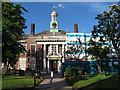
2
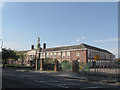
John Roan School, refurbished
A recent refurbishment of the Maze Hill site of the school had recently been completed.
The school, a 17th century foundation, moved to this site in the 1920s and now operates on several sites in the area. The building is listed grade 2 (list entry number 1393296); it dates from 1926-28 and is to the designs of Sir Bannister Fletcher and P B Dannatt.
Image: © Stephen Craven
Taken: 1 Jul 2015
0.01 miles
3
The John Roan School (upper School), Greenwich (2)
A Grade II listed school. As seen from Highmore Place.
See Link for more details about the building.
Image: © David Anstiss
Taken: 11 Sep 2011
0.02 miles
4
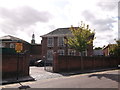
Entrance to John Roan School
The original entrance to the school on Maze Hill. The school, a 17th century foundation, moved to this site in the 1920s and now operates on several sites in the area. The building is listed grade 2 (list entry number 1393296); it dates from 1926-28 and is to the designs of Sir Bannister Fletcher and P B Dannatt.
Image: © Stephen Craven
Taken: 27 May 2013
0.02 miles
5
The John Roan School (upper School), Greenwich
A Grade II listed school. As seen from Vanbrugh Fields.
See http://www.britishlistedbuildings.co.uk/en-504217-the-john-roan-school-upper-school-greenw for more details about the building.
Image: © David Anstiss
Taken: 11 Sep 2011
0.02 miles
6
John Roan School - main entrance, refurbished
A recent refurbishment of the Maze Hill site of the school had recently been completed. See Image for an earlier photo. The clock is not working, though: this photo was actually taken around 6pm.
The school, a 17th century foundation, moved to this site in the 1920s and now operates on several sites in the area. The building is listed grade 2 (list entry number 1393296); it dates from 1926-28 and is to the designs of Sir Bannister Fletcher and P B Dannatt.
Image: © Stephen Craven
Taken: 1 Jul 2015
0.03 miles
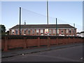
7
John Roan School, playground
A tarmac surfaced area to the south of the main school building.
Image: © Stephen Craven
Taken: 1 Jul 2015
0.03 miles
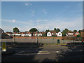
8
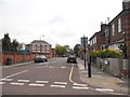
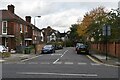
Highmore Road at the junction of Vanbrugh Fields
Image: © David Howard
Taken: 27 Apr 2014
0.04 miles
9
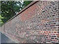
Patchwork brick wall, Greenwich Park
The high brick walls around the park are listed grade 2 (list entry number 1290730). This stretch on Maze Hill shows historical development with patch repairs using various shades of brick, and both cement and lime mortar (conservationists much prefer lime mortar).
Image: © Stephen Craven
Taken: 1 Jul 2015
0.05 miles