IMAGES TAKEN NEAR TO
Seren Park Gardens, LONDON, SE3 7RP
Introduction
This page details the photographs taken nearby to Seren Park Gardens, SE3 7RP by members of the Geograph project.
The Geograph project started in 2005 with the aim of publishing, organising and preserving representative images for every square kilometre of Great Britain, Ireland and the Isle of Man.

There are currently over 7.5m images from over14,400 individuals and you can help contribute to the project by visiting https://www.geograph.org.uk
Image Map
Images are licensed for reuse under creativecommons.org/licenses/by-sa/2.0
Notes
- Clicking on the map will re-center to the selected point.
- The higher the marker number, the further away the image location is from the centre of the postcode.
Image Listing (262 Images Found)
Images are licensed for reuse under creativecommons.org/licenses/by-sa/2.0
Image
Details
Distance
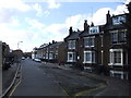
1
Seren Park
Several medium-rise blocks comprise this housing development adjacent to Maze Hill station, built c.2005.
See also Image
Image: © Stephen Craven
Taken: 9 Jul 2011
0.02 miles
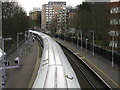
3
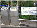
Oyster card readers
These smartcard readers are on platform 2 of Maze Hill station, at the top of the access ramp from Woodlands Park Road. A sign gives directions to various local venues (including "Cutty Sark 1180 yards"), although that particular attraction is in fact closer to Greenwich railway station than this one.
Image: © Stephen Craven
Taken: 9 Jul 2011
0.04 miles
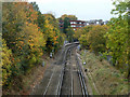
4
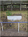
Remains of a subway
I had passed this small piece of brickwork several times without giving it any attention, before a local resident told me he could remember as a boy using a pedestrian subway under the railway line here. He presumed the brickwork is the top of the northern portal of the filled-in subway. The handrail in the foreground is on a more recent access ramp to the station platform. The photo is taken from rail level. In idea of what it might have looked like can be got from comparing one 3km further east on the same line: Image
Image: © Stephen Craven
Taken: 9 Jul 2011
0.04 miles
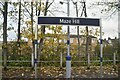
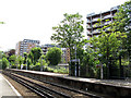
6
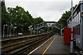
Maze Hill station, looking east
A local train to Dartford is about to leave.
Image: © Peter Whatley
Taken: 5 Apr 2010
0.05 miles
7
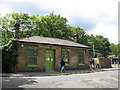
Original station entrance, Maze Hill
This building is now the Maze Hill Pottery, but according to a local resident used to be the booking office for the railway station behind it.
Image: © Stephen Craven
Taken: 9 Jul 2011
0.05 miles
9
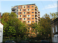
Housing block on Restell Close
This is one of several medium-rise blocks built c.2005 immediately to the south of the railway line. The photo was taken from Earlswood Street on the other side of the railway.
Image: © Stephen Craven
Taken: 19 Apr 2011
0.06 miles