IMAGES TAKEN NEAR TO
Foyle Road, LONDON, SE3 7RH
Introduction
This page details the photographs taken nearby to Foyle Road, SE3 7RH by members of the Geograph project.
The Geograph project started in 2005 with the aim of publishing, organising and preserving representative images for every square kilometre of Great Britain, Ireland and the Isle of Man.

There are currently over 7.5m images from over14,400 individuals and you can help contribute to the project by visiting https://www.geograph.org.uk
Image Map
Images are licensed for reuse under creativecommons.org/licenses/by-sa/2.0
Notes
- Clicking on the map will re-center to the selected point.
- The higher the marker number, the further away the image location is from the centre of the postcode.
Image Listing (99 Images Found)
Images are licensed for reuse under creativecommons.org/licenses/by-sa/2.0
Image
Details
Distance
1
Ulundi Road at the junction of Vanbrugh Hill
Image: © David Howard
Taken: 27 Apr 2014
0.07 miles
2
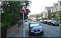
Vanbrugh Hill - Steep Hill 17%
Vanbrugh Hill, Greenwich. 17% steep hill down sign.
Image: © Adam Morse
Taken: 8 Aug 2009
0.07 miles
3

Lasseter Place, near Greenwich
Lasseter Place is a small cul-de-sac off Vanbrugh Hill near Greenwich in South East London
Image: © Malc McDonald
Taken: 23 Jul 2011
0.09 miles
4
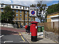
Postbox on Humber Road
The box is at the west end of Humber Road. The 'drop-box' on the far side had just been emptied by the delivery worker on his rounds (he can be seen walking round the corner).
The sign behind the postbox is for a controlled parking zone (CPZ).
Image: © Stephen Craven
Taken: 9 Jul 2011
0.10 miles
5

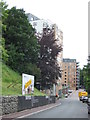
Vanbrugh Hill, near Greenwich
Vanbrugh Hill is a steep hill, this can be seen by looking at the brickwork on the opposite side of the road.
Image: © Malc McDonald
Taken: 23 Jul 2011
0.11 miles
6
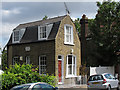
Thistle Cottage, Dinsdale Road
This property has architectural charm with features such as arched brick lintels to the doors and windows, and a dual-pitched roof. It seems out of place among the rows of 19th century terraced housing in the area.
Image: © Stephen Craven
Taken: 9 Jul 2011
0.11 miles
7
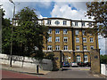
Woodland Heights, Vanbrugh Hill
This property is now let out as several apartments, but was clearly a single address originally. I have not yet been able to find its history.
The photo shows the steep gradient of Vanbrugh Hill - at 17% one of the steepest roads in the area Image Surprisingly, it is on a bus route (386) although the buses get diverted in the case of snow or ice on the road.
Image: © Stephen Craven
Taken: 9 Jul 2011
0.11 miles
9
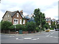
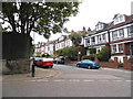
Houses on Westcombe Park Road, Blackheath
Suburban houses on Westcombe Park Road, at Blackheath in South East London. In the foreground, the road junction comprises a mini-roundabout.
Image: © Malc McDonald
Taken: 23 Jul 2011
0.12 miles
10
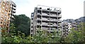
Restell Close, near Greenwich
Restell Close leads to newly-built blocks of flats near Greenwich in South East London.
Image: © Malc McDonald
Taken: 23 Jul 2011
0.13 miles