IMAGES TAKEN NEAR TO
Vanbrugh Park Road West, LONDON, SE3 7QD
Introduction
This page details the photographs taken nearby to Vanbrugh Park Road West, SE3 7QD by members of the Geograph project.
The Geograph project started in 2005 with the aim of publishing, organising and preserving representative images for every square kilometre of Great Britain, Ireland and the Isle of Man.

There are currently over 7.5m images from over14,400 individuals and you can help contribute to the project by visiting https://www.geograph.org.uk
Image Map
Images are licensed for reuse under creativecommons.org/licenses/by-sa/2.0
Notes
- Clicking on the map will re-center to the selected point.
- The higher the marker number, the further away the image location is from the centre of the postcode.
Image Listing (97 Images Found)
Images are licensed for reuse under creativecommons.org/licenses/by-sa/2.0
Image
Details
Distance
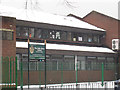
1
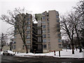
Westcombe Court
A very distinctive H-shaped eight-storey concrete housing block that forms the centrepiece of the Vanbrugh Park council estate.
Image: © Stephen Craven
Taken: 5 Feb 2012
0.04 miles
2
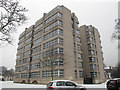
Westcombe Court
A very distinctive H-shaped eight-storey concrete housing block that forms the centrepiece of the Vanbrugh Park council estate.
Image: © Stephen Craven
Taken: 5 Feb 2012
0.05 miles
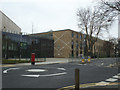
3
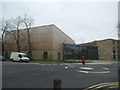
John Roan School new buildings (1)
The buildings on the Westcombe Park Road site of John Roan secondary school Image were demolished in 2012, rebuilt Image and reopened in September 2014.
Image: © Stephen Craven
Taken: 14 Mar 2015
0.05 miles
4
Rebuilding of John Roan School
See Image and Image for the previous building on the site before demolition. The replacement school buildings opened in 2014 Image
Image: © Stephen Craven
Taken: 29 Sep 2013
0.06 miles
5
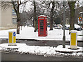
Phone box and bollards
A traditional red phone box on Westcombe Park Road, framed by a pair of bollards on a pedestrian refuge.
Image: © Stephen Craven
Taken: 5 Feb 2012
0.06 miles
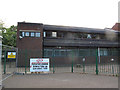
6
John Roan School (new site)
The John Roan school is a secondary school on two sites in the Maze Hill area. This is the newer building (c.1970?) on Westcombe Park Road, but it is scheduled for a complete rebuild from 2012 onwards. See http://www.thejohnroanschoolbsf.co.uk/wp/?page_id=73. The older building nearby Image will be retained and refurbished.
Image: © Stephen Craven
Taken: 5 Feb 2012
0.08 miles
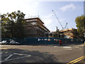
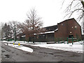
8
John Roan School: demolition about to start
These buildings on Westcombe Park Road, one of the two sites of the school Image, were demolished in August 2012.
Image: © Stephen Craven
Taken: 8 Aug 2012
0.08 miles
9
John Roan School - detail
Part of the Westcombe Park Road site Image, showing the sign board with the school motto "honore et labore". This building is scheduled for a complete rebuild from 2012 onwards. See http://www.thejohnroanschoolbsf.co.uk/wp/?page_id=73.
Image: © Stephen Craven
Taken: 5 Feb 2012
0.08 miles
10
John Roan School new buildings (2)
The buildings on the Westcombe Park Road site of John Roan secondary school Image were demolished in 2012, rebuilt Image and reopened in September 2014.
Image: © Stephen Craven
Taken: 14 Mar 2015
0.08 miles