IMAGES TAKEN NEAR TO
Beaconsfield Close, LONDON, SE3 7LJ
Introduction
This page details the photographs taken nearby to Beaconsfield Close, SE3 7LJ by members of the Geograph project.
The Geograph project started in 2005 with the aim of publishing, organising and preserving representative images for every square kilometre of Great Britain, Ireland and the Isle of Man.

There are currently over 7.5m images from over14,400 individuals and you can help contribute to the project by visiting https://www.geograph.org.uk
Image Map (Loading...)


Getting Data...Please wait
Leaflet Map data © OpenStreetMap
Images are licensed for reuse under creativecommons.org/licenses/by-sa/2.0
Notes
- Clicking on the map will re-center to the selected point.
- The higher the marker number, the further away the image location is from the centre of the postcode.
Image Listing (117 Images Found)
Images are licensed for reuse under creativecommons.org/licenses/by-sa/2.0
Image
Details
Distance
1
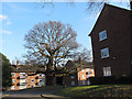
Tree in the centre of Beaconsfield Close
The Close was obviously built around this venerable tree.
Image: © Stephen Craven
Taken: 6 Apr 2013
0.02 miles
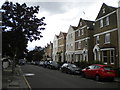
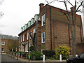
2
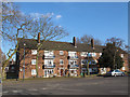
Housing on Beaconsfield Close
The Close consists of several three-storey blocks of flats like this one.
Image: © Stephen Craven
Taken: 6 Apr 2013
0.03 miles
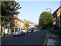
3
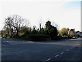
The Hardy Road triangle
The junction between Hardy Road and Beaconsfield Road is occupied by this triangular open space. Local folk memory is that St George's church Image was intended to be built here, but for some reason ended up on Kirkside Road a few hundred metres away.
The triangle sits astride a grid line, so the view from the other side Image is allocated to the next square.
Image: © Stephen Craven
Taken: 6 Apr 2013
0.06 miles
4
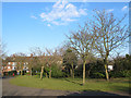
Inside the Hardy Road triangle
The junction between Hardy Road and Beaconsfield Road is occupied by this triangular open space. Local folk memory is that St George's church Image was intended to be built here, but for some reason ended up on Kirkside Road a few hundred metres away.
The triangle sits astride a grid line, so the view from the other side Image is allocated to the next square.
Image: © Stephen Craven
Taken: 6 Apr 2013
0.07 miles

8
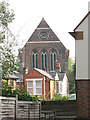
West end of St George's church
This Anglican church, despite its great height, is almost hidden by trees and buildings. This glimpse of the west end of the church between two houses on Mycenae Road is one of the few views possible.
Image: © Stephen Craven
Taken: 10 Oct 2010
0.10 miles
9
Woodlands, Mycenae Road
This building is used by a Steiner School.
Image: © Stephen Craven
Taken: 25 Nov 2010
0.11 miles
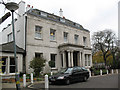
10
Mycenae House
This building on Mycenae Road was formerly a grand private house on Mycenae Road, at one time home to the Greenwich local history library, and now a community centre.
Image: © Stephen Craven
Taken: 25 Nov 2010
0.11 miles