IMAGES TAKEN NEAR TO
Invicta Road, LONDON, SE3 7HD
Introduction
This page details the photographs taken nearby to Invicta Road, SE3 7HD by members of the Geograph project.
The Geograph project started in 2005 with the aim of publishing, organising and preserving representative images for every square kilometre of Great Britain, Ireland and the Isle of Man.

There are currently over 7.5m images from over14,400 individuals and you can help contribute to the project by visiting https://www.geograph.org.uk
Image Map
Images are licensed for reuse under creativecommons.org/licenses/by-sa/2.0
Notes
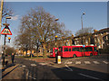
- Clicking on the map will re-center to the selected point.
- The higher the marker number, the further away the image location is from the centre of the postcode.
Image Listing (260 Images Found)
Images are licensed for reuse under creativecommons.org/licenses/by-sa/2.0
Image
Details
Distance
3
London 2012 banner
Banners like this were hung from lamp-posts all around the city. This example is on Charlton Road SE3, adjacent to a bus stop.
Image: © Stephen Craven
Taken: 8 Aug 2012
0.03 miles
4
Bus stand at Blackheath Royal Standard
The 202 bus route from Crystal Palace terminates here, and a parking bay is provided for up to two buses so that their drivers can take rest breaks between turns. It is located over the railway tunnel Image
Image: © Stephen Craven
Taken: 16 Jan 2011
0.05 miles
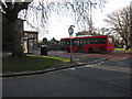
5
202 bus stand
The 202 bus route from Crystal Palace terminates here. Two buses stand awaiting their next duty. As it happens they are directly over the railway tunnel between Charlton and Blackheath.
Image: © Stephen Craven
Taken: 6 Apr 2013
0.05 miles
6
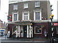
Blackheath, Royal Standard
For many years the name of the Royal Standard pub has been used to describe the locality. It's located about half a mile from the start of the London Marathon
Image: © David Hatch
Taken: 5 Jan 2002
0.05 miles
7
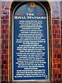
Blackheath, Royal Standard
Unfortunately, this interesting sign that explains the Royal Standard's history was removed during a recent renovation and wasn't replaced
Image: © David Hatch
Taken: 5 Jan 2002
0.05 miles
8
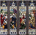
St John the Evangelist, Stratheden Road, Blackheath - Stained glass window
Image: © John Salmon
Taken: 18 Sep 2014
0.05 miles
9
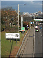
A plethora of signs
Signs lining this short 150m section of the northbound A102 at Charlton warn of police speed cameras, give directions to the O2 leisure venue (its trademark yellow columns visible to the left of the photo), warn of parking restrictions on the road and height restrictions in the tunnel ahead, and above them all is a massive digital display used to warn of tunnel closures or other roadworks.
Image: © Stephen Craven
Taken: 16 Jan 2011
0.05 miles
10
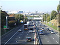
A102 road at Blackheath
The A102 is a trunk dual-carriageway which cuts through South East London, linking the A2 road with the Blackwall Tunnel. The tunnel takes traffic beneath the River Thames and into East London.
The sign to the left of the road advises motorists heading for the O2 to follow the pictogram signs. The O2 building itself is visible in the background.
The O2 was previously known as the Millennium Dome. During the year 2000 it housed an exhibition, but has now been converted into a leisure complex with a cinema, restaurants and an arena for live events.
Image: © Malc McDonald
Taken: 22 Oct 2011
0.05 miles