IMAGES TAKEN NEAR TO
Mycenae Road, LONDON, SE3 7AX
Introduction
This page details the photographs taken nearby to Mycenae Road, SE3 7AX by members of the Geograph project.
The Geograph project started in 2005 with the aim of publishing, organising and preserving representative images for every square kilometre of Great Britain, Ireland and the Isle of Man.

There are currently over 7.5m images from over14,400 individuals and you can help contribute to the project by visiting https://www.geograph.org.uk
Image Map
Images are licensed for reuse under creativecommons.org/licenses/by-sa/2.0
Notes
- Clicking on the map will re-center to the selected point.
- The higher the marker number, the further away the image location is from the centre of the postcode.
Image Listing (109 Images Found)
Images are licensed for reuse under creativecommons.org/licenses/by-sa/2.0
Image
Details
Distance
1
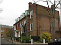
Mycenae House
This building on Mycenae Road was formerly a grand private house on Mycenae Road, at one time home to the Greenwich local history library, and now a community centre.
Image: © Stephen Craven
Taken: 25 Nov 2010
0.02 miles
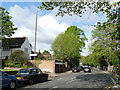
2
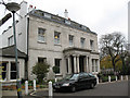
Woodlands, Mycenae Road
This building is used by a Steiner School.
Image: © Stephen Craven
Taken: 25 Nov 2010
0.03 miles
3
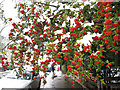
Berries with snow
A magnificent winter display of berries on a bush overhanging Westcombe Park Road.
Technical note: taken with the help of fill-in flash.
Image: © Stephen Craven
Taken: 5 Feb 2012
0.07 miles
4
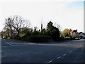
The Hardy Road triangle
The junction between Hardy Road and Beaconsfield Road is occupied by this triangular open space. Local folk memory is that St George's church Image was intended to be built here, but for some reason ended up on Kirkside Road a few hundred metres away.
The triangle sits astride a grid line, so the view from the other side Image is allocated to the next square.
Image: © Stephen Craven
Taken: 6 Apr 2013
0.09 miles
5
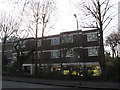
Housing on Beaconsfield Road
The design of this block of flats is unusual - two storeys of accommodation supported on columns but with nothing occupying the space beneath. An arrangement that would make sense in a flood plain, but this is at the top of a 40m hill!
Image: © Stephen Craven
Taken: 6 Apr 2013
0.09 miles
6
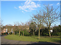
Inside the Hardy Road triangle
The junction between Hardy Road and Beaconsfield Road is occupied by this triangular open space. Local folk memory is that St George's church Image was intended to be built here, but for some reason ended up on Kirkside Road a few hundred metres away.
The triangle sits astride a grid line, so the view from the other side Image is allocated to the next square.
Image: © Stephen Craven
Taken: 6 Apr 2013
0.09 miles
7
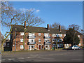
Housing on Beaconsfield Close
The Close consists of several three-storey blocks of flats like this one.
Image: © Stephen Craven
Taken: 6 Apr 2013
0.09 miles
8
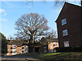
Tree in the centre of Beaconsfield Close
The Close was obviously built around this venerable tree.
Image: © Stephen Craven
Taken: 6 Apr 2013
0.11 miles
9

Glenluce Road, Blackheath
Some large houses at the top of Glenluce Road. These are now selling for not far off a million pounds.
Image: © Stephen Craven
Taken: 8 Feb 2015
0.12 miles
10
Westcombe Park Road
The sign to the "Church of England Parish Church" (St George's) is a recent addition.
Image: © Stephen Craven
Taken: 28 Apr 2019
0.13 miles