IMAGES TAKEN NEAR TO
The Paragon, LONDON, SE3 0PA
Introduction
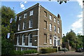
This page details the photographs taken nearby to The Paragon, SE3 0PA by members of the Geograph project.
The Geograph project started in 2005 with the aim of publishing, organising and preserving representative images for every square kilometre of Great Britain, Ireland and the Isle of Man.

There are currently over 7.5m images from over14,400 individuals and you can help contribute to the project by visiting https://www.geograph.org.uk
Image Map
Images are licensed for reuse under creativecommons.org/licenses/by-sa/2.0
Notes
- Clicking on the map will re-center to the selected point.
- The higher the marker number, the further away the image location is from the centre of the postcode.
Image Listing (78 Images Found)
Images are licensed for reuse under creativecommons.org/licenses/by-sa/2.0
Image
Details
Distance
8
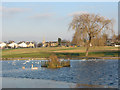
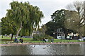
Blackheath Pond
The pond at the eastern end of the heath was reconstructed with a concrete lining in about 2005 and can be artificially topped up. It attracts common water birds such as swans and ducks. The church in the background is St John's.
Image: © Stephen Craven
Taken: 16 Dec 2007
0.07 miles