IMAGES TAKEN NEAR TO
The Paragon, LONDON, SE3 0NZ
Introduction
This page details the photographs taken nearby to The Paragon, SE3 0NZ by members of the Geograph project.
The Geograph project started in 2005 with the aim of publishing, organising and preserving representative images for every square kilometre of Great Britain, Ireland and the Isle of Man.

There are currently over 7.5m images from over14,400 individuals and you can help contribute to the project by visiting https://www.geograph.org.uk
Image Map
Images are licensed for reuse under creativecommons.org/licenses/by-sa/2.0
Notes
- Clicking on the map will re-center to the selected point.
- The higher the marker number, the further away the image location is from the centre of the postcode.
Image Listing (77 Images Found)
Images are licensed for reuse under creativecommons.org/licenses/by-sa/2.0
Image
Details
Distance
8
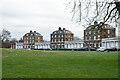
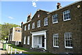
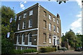
Blackheath : The Paragon
Grade I listed terrace built in 1790. More at this https://historicengland.org.uk/listing/the-list/list-entry/1211997.
Image: © Jim Osley
Taken: 23 Jan 2023
0.07 miles
9
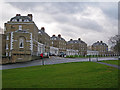
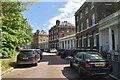
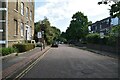
The Paragon, SE3
These flats overlook the heath.
Image: © Danny P Robinson
Taken: 25 Feb 2007
0.07 miles