IMAGES TAKEN NEAR TO
Wricklemarsh Road, LONDON, SE3 0NE
Introduction
This page details the photographs taken nearby to Wricklemarsh Road, SE3 0NE by members of the Geograph project.
The Geograph project started in 2005 with the aim of publishing, organising and preserving representative images for every square kilometre of Great Britain, Ireland and the Isle of Man.

There are currently over 7.5m images from over14,400 individuals and you can help contribute to the project by visiting https://www.geograph.org.uk
Image Map (Loading...)


Getting Data...Please wait
Leaflet Map data © OpenStreetMap
Images are licensed for reuse under creativecommons.org/licenses/by-sa/2.0
Notes
- Clicking on the map will re-center to the selected point.
- The higher the marker number, the further away the image location is from the centre of the postcode.
Image Listing (61 Images Found)
Images are licensed for reuse under creativecommons.org/licenses/by-sa/2.0
Image
Details
Distance
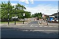
3
Brook Lane, SE3
The 1930s OS map http://openspace.nearby.org.uk/wheresthepath.htm?lat=51.46871244324136&lon=0.02772461178761682&gz=14&oz=9>=5 shows that Middle Kid Brook ran NE - SW at the bottom of Brook Lane; its source was not far to the northeast, near the junction of Wricklemarsh Road and Weyman Road.
Image: © Mike Quinn
Taken: 2 Sep 2010
0.05 miles
5
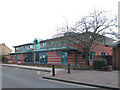
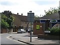
Brook Lane medical centre
The road is presumably named after the Kid Brook which flows mainly underground near here.
Image: © Stephen Craven
Taken: 19 Feb 2012
0.07 miles
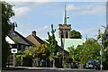
6

Interior of St James's church
The interior of Image The church is 19th century in origin but was badly damaged in World War 2 so the roof and windows are all post-war. The presence of a projector screen is increasingly common in churches; whether it spoils the view of the interior is a matter of opinion.
Image: © Stephen Craven
Taken: 9 Feb 2009
0.07 miles
8
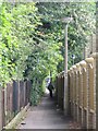
Footpath between Kidbrooke Park Road (A2213) and Kidbrooke Grove, SE3 (2)
Image: © Mike Quinn
Taken: 2 Sep 2010
0.07 miles
9
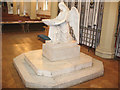
Font in St James's church
A very unusual design of font, in the shape of an angel, although I have since seen two identical ones, in Inverness Episcopal cathedral Image and in Copenhagen, which is said to be the original. The Historic England listing dates it to 1898. For an exterior view of the church, see Image
Image: © Stephen Craven
Taken: 9 Feb 2009
0.07 miles
10
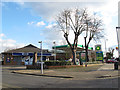
Brook Lane filling station
A BP filling station and convenience store on the corner of Brook Lane and Kidbrooke Park Road. At this time prices were petrol 134.9p and diesel 141.9p per litre.
Image: © Stephen Craven
Taken: 19 Feb 2012
0.08 miles