IMAGES TAKEN NEAR TO
Kidbrooke Way, LONDON, SE3 0DY
Introduction
This page details the photographs taken nearby to Kidbrooke Way, SE3 0DY by members of the Geograph project.
The Geograph project started in 2005 with the aim of publishing, organising and preserving representative images for every square kilometre of Great Britain, Ireland and the Isle of Man.

There are currently over 7.5m images from over14,400 individuals and you can help contribute to the project by visiting https://www.geograph.org.uk
Image Map
Images are licensed for reuse under creativecommons.org/licenses/by-sa/2.0
Notes
- Clicking on the map will re-center to the selected point.
- The higher the marker number, the further away the image location is from the centre of the postcode.
Image Listing (49 Images Found)
Images are licensed for reuse under creativecommons.org/licenses/by-sa/2.0
Image
Details
Distance
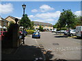
1
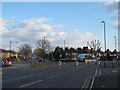
Rochester Way junction
The junction of Kidbrooke Park Road (foreground and bearing right), Rochester Way (straight ahead), and Susan Road (the slip-road to the left which turns into a housing estate).
Image: © Stephen Craven
Taken: 19 Feb 2012
0.02 miles
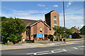
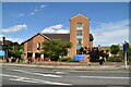
4
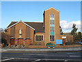
Church of St John Fisher
A Roman Catholic church on Kidbrooke Park Road. For information about its patron saint, see http://en.wikipedia.org/wiki/John_Fisher
Image: © Stephen Craven
Taken: 19 Feb 2012
0.04 miles
5
Dover Patrol SE3
The 'Dover Patrol' was a pub on the busy A2, with a pub sign showing a boat in the choppy waters of the English Channel. However, the opening of the new A102M motorway from the Blackwall Tunnel out towards Kent cut it off from its passing trade. In the 1980s it closed and in the 1990s it was demolished and replaced with a small housing development.
Image: © David Hatch
Taken: 18 Jun 2005
0.04 miles
6
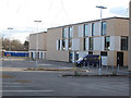
Thomas Tallis School, new buildings (2)
The new buildings for this secondary school were built in 2010/11 on the original school's playing fields adjacent to Kidbrooke Park Road. See Image for the other half of the frontage.
Image: © Stephen Craven
Taken: 19 Feb 2012
0.05 miles
7
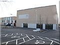
Thomas Tallis School, new buildings (1)
The new buildings for this secondary school were built in 2010/11 on the original school's playing fields adjacent to Kidbrooke Park Road. See Image for this building under construction.
Image: © Stephen Craven
Taken: 19 Feb 2012
0.05 miles
8
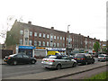
Parade of shops on Rochester Way, Kidbrooke
Rochester Way lost its status as a main road years ago when the parallel A2 dual carriageway was built, but this parade of shops survives. The flats above them are known as Gregory House.
Image: © Stephen Craven
Taken: 9 May 2009
0.05 miles
9
Kidbrooke Park Road (A2213), SE3 (2)
The bushes to the right of the blue and white hoarding (left) mark where Middle Kid Brook passes under the road - see Image
Image: © Mike Quinn
Taken: 2 Sep 2010
0.06 miles
10
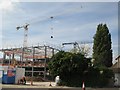
School building site west of Kidbrooke Park Road (A2213), SE3
The bushes (half right) mark where Middle Kid Brook passes under the road - see Image
Image: © Mike Quinn
Taken: 2 Sep 2010
0.07 miles