IMAGES TAKEN NEAR TO
Andwell Close, LONDON, SE2 9XT
Introduction
This page details the photographs taken nearby to Andwell Close, SE2 9XT by members of the Geograph project.
The Geograph project started in 2005 with the aim of publishing, organising and preserving representative images for every square kilometre of Great Britain, Ireland and the Isle of Man.

There are currently over 7.5m images from over14,400 individuals and you can help contribute to the project by visiting https://www.geograph.org.uk
Image Map
Images are licensed for reuse under creativecommons.org/licenses/by-sa/2.0
Notes
- Clicking on the map will re-center to the selected point.
- The higher the marker number, the further away the image location is from the centre of the postcode.
Image Listing (26 Images Found)
Images are licensed for reuse under creativecommons.org/licenses/by-sa/2.0
Image
Details
Distance
3
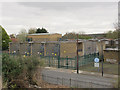
Sewell Road transformer station
Sewell Road is the main National Grid transformer station for the Plumstead / Thamesmead area.
A 2006 document http://legacy.london.gov.uk/mayor/planning/srdf/docs/east-srdf-annexes.rtf reported that by 2016 it would need to be upgraded from 4x15 MVA to 3x60 MVA transformers, the incoming supply being increased from 33kV to 132kV, to meet the increased demand from housing developments in the area. In this photo there are clearly four, not three transformers so it is not clear whether this upgrade has taken place yet.
To the right is part of the Thames Water Pumping Station. I have not been able to discover anything online about this facility, although I guess that it pumps sewage from the local area (Abbey Wood) into the Southern Outfall Sewer (the photo being taken from the Ridgeway path on top of said sewer).
Image: © Stephen Craven
Taken: 19 Apr 2015
0.06 miles
4
Shops on Grovebury Road, near Abbey Wood
A parade of shops beneath a block of flats on Grovebury Road, near Abbey Wood in the outer suburbs of south east London.
Image: © Malc McDonald
Taken: 18 Sep 2021
0.07 miles
5
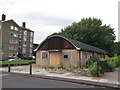
Former Nissen Hut, Abbey Wood
This building on Grovebury Road, was a former World War II air raid shelter.
Image: © David Anstiss
Taken: 21 Aug 2011
0.07 miles
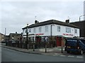
6
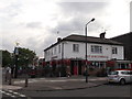
The Birchwood Public House, Abbey Wood
On the junction of Ampleforth Road (on the left) and Grovebury Road (on the right).
Image: © David Anstiss
Taken: 21 Aug 2011
0.07 miles
7
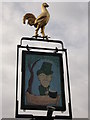
The Birchwood Pub Sign, Abbey Wood
Outside Image
Image: © David Anstiss
Taken: 21 Aug 2011
0.07 miles
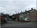
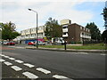
10
Sewell Road - new housing
This three-storey block of housing with car parking outside looks newer than most of the housing in the area. It is opposite an access point to the Ridgeway.
Image: © Stephen Craven
Taken: 19 Apr 2015
0.12 miles