IMAGES TAKEN NEAR TO
Wolvercote Road, LONDON, SE2 9TF
Introduction
This page details the photographs taken nearby to Wolvercote Road, SE2 9TF by members of the Geograph project.
The Geograph project started in 2005 with the aim of publishing, organising and preserving representative images for every square kilometre of Great Britain, Ireland and the Isle of Man.

There are currently over 7.5m images from over14,400 individuals and you can help contribute to the project by visiting https://www.geograph.org.uk
Image Map (Loading...)


Getting Data...Please wait
Leaflet Map data © OpenStreetMap
Images are licensed for reuse under creativecommons.org/licenses/by-sa/2.0
Notes
- Clicking on the map will re-center to the selected point.
- The higher the marker number, the further away the image location is from the centre of the postcode.
Image Listing (41 Images Found)
Images are licensed for reuse under creativecommons.org/licenses/by-sa/2.0
Image
Details
Distance
1
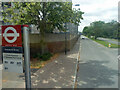
Yarnton Way from westbound Hartslock Drive bus stop
Looking from a bus on route 180.
Image: © Robin Webster
Taken: 25 Jun 2011
0.06 miles
2

Thamesmead tower blocks
The six tower blocks along Yarnton Way (with four behind at Southmere) viewed from the hillside above Lesnes Abbey.
Image: © Stephen Craven
Taken: 15 Jan 2012
0.06 miles
3
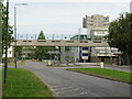
Yarnton Way, Thamesmead
Yarnton Way in Thamesmead. This was the first area of Thamesmead to be developed. A concrete bridge carries a walkway across the road, which is a dual carriageway.
Image: © Malc McDonald
Taken: 18 Sep 2021
0.07 miles
4

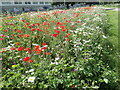
Alongside the Green Chain Walk on Thamesmead
This superb show of wild flowers are mostly those which would formerly be found in corn fields. They were seen in the first half of June alongside the Green Chain Walk on Thamesmead between Abbey Road and Yarnton Way. Apart from poppies, cornflowers, corncockles, corn marigolds and ox-eye daisies were prominent. I had never seen so many cornflowers.
Image: © Marathon
Taken: 9 Jun 2022
0.08 miles
5

Church of the Cross, Lensbury Way, Thamesmead - Interior
Image: © John Salmon
Taken: 13 Jul 2010
0.09 miles
6
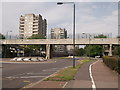
Footbridge over Yanton Way
A dual carriage way leads through Thamesmead and Abbey Wood housing estate.
The bridge is used by the Green Chain Walk (long distance path) between Abbey Wood and Thamesmead.
Image: © David Anstiss
Taken: 21 Aug 2011
0.09 miles
7
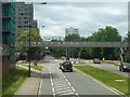
Yarnton Way at the Wolvercote Road roundabout
Viewed from a bus on route 180.
Image: © Robin Webster
Taken: 25 Jun 2011
0.09 miles
8
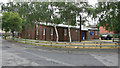
Church of the Cross, Lensbury Way, Thamesmead
Image: © John Salmon
Taken: 13 Jul 2010
0.09 miles
9
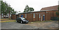
Church of the Cross, Lensbury Way, Thamesmead
Image: © John Salmon
Taken: 13 Jul 2010
0.10 miles
10
Alongside the Green Chain Walk on Thamesmead
This superb show of wild flowers are mostly those which would formerly be found in corn fields. They were seen in the first half of June alongside the Green Chain Walk on Thamesmead between Abbey Road and Yarnton Way. Apart from poppies, cornflowers, corncockles, corn marigolds and ox-eye daisies were prominent.
Image: © Marathon
Taken: 9 Jun 2022
0.10 miles