IMAGES TAKEN NEAR TO
Dalberg Way, LONDON, SE2 9SL
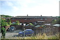
Introduction
This page details the photographs taken nearby to Dalberg Way, SE2 9SL by members of the Geograph project.
The Geograph project started in 2005 with the aim of publishing, organising and preserving representative images for every square kilometre of Great Britain, Ireland and the Isle of Man.

There are currently over 7.5m images from over14,400 individuals and you can help contribute to the project by visiting https://www.geograph.org.uk
Image Map
Images are licensed for reuse under creativecommons.org/licenses/by-sa/2.0
Notes
- Clicking on the map will re-center to the selected point.
- The higher the marker number, the further away the image location is from the centre of the postcode.
Image Listing (141 Images Found)
Images are licensed for reuse under creativecommons.org/licenses/by-sa/2.0
Image
Details
Distance
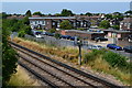
1
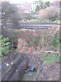
Water main under the railway
Work on relaying a water main gave a rare chance to see where it crosses under the railway embankment. Viewed from Image
Image: © Stephen Craven
Taken: 7 Dec 2008
0.04 miles
2
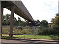
Footbridge over Railway
This bridge leads from the green near Manor Way, over Sydney Road and the railway towards Lesnes Abbey.
The bridge is used by the Green Chain Walk (long distance path) from the River Thames towards Lesnes Abbey Woods.
Image: © David Anstiss
Taken: 21 Aug 2011
0.05 miles
3
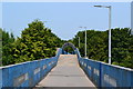
Footbridge and high level walkway, Lesnes
Image: © David Martin
Taken: 12 Jul 2013
0.05 miles
4
View across railway line from footbridge at Lesnes
Image: © David Martin
Taken: 12 Jul 2013
0.05 miles
5
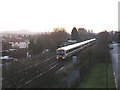
Eastbound train near Abbey Wood
A Southeastern service on the long straight section east of Abbey Wood station, in 2-2-4 formation (two 2-car class 466 units and one 4-car class 465).
Image: © Stephen Craven
Taken: 7 Dec 2008
0.05 miles
6
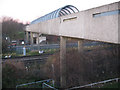
Footbridge near Abbey Wood station
The footbridge is not at the station itself but a few hundred metres east, and forms part of the Green Chain Walk, although most users of the bridge are probably residents of the estates either side of the railway. The metal grille forming an arch over the bridge above the tracks is relatively recent (between 2006 and 2008) and is presumably to prevent objects being thrown onto the railway line.
Image: © Stephen Craven
Taken: 7 Dec 2008
0.05 miles
7
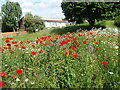
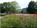
Cornfield annuals on Thamesmead
This superb show of wild flowers are mostly those which would formerly be found in corn fields. They were seen in the first half of June alongside the Green Chain Walk on Thamesmead between Abbey Road and Yarnton Way. Apart from poppies, cornflowers, corncockles, corn marigolds and ox-eye daisies were prominent. I had never seen so many cornflowers.
Image: © Marathon
Taken: 9 Jun 2022
0.05 miles
8
Cornfield annuals on Thamesmead
This superb show of wild flowers are mostly those which would formerly be found in corn fields. They were seen in the first half of June alongside the Green Chain Walk on Thamesmead between Abbey Road and Yarnton Way. Apart from poppies, cornflowers, corncockle, corn marigold and ox-eye daisies were prominent. I had never seen so many cornflowers.
Image: © Marathon
Taken: 9 Jun 2022
0.05 miles
9
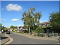
Lanridge Road, Thamesmead
Lanridge Road is a residential road in Thamesmead.
Image: © Malc McDonald
Taken: 8 Oct 2022
0.06 miles