IMAGES TAKEN NEAR TO
Thistlebrook Industrial Estate, Eynsham Drive, LONDON, SE2 9RB
Introduction
This page details the photographs taken nearby to Thistlebrook Industrial Estate, Eynsham Drive, SE2 9RB by members of the Geograph project.
The Geograph project started in 2005 with the aim of publishing, organising and preserving representative images for every square kilometre of Great Britain, Ireland and the Isle of Man.

There are currently over 7.5m images from over14,400 individuals and you can help contribute to the project by visiting https://www.geograph.org.uk
Image Map
Images are licensed for reuse under creativecommons.org/licenses/by-sa/2.0
Notes
- Clicking on the map will re-center to the selected point.
- The higher the marker number, the further away the image location is from the centre of the postcode.
Image Listing (34 Images Found)
Images are licensed for reuse under creativecommons.org/licenses/by-sa/2.0
Image
Details
Distance
1
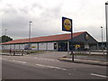
Lidl Supermarket Abbey Wood
Budget supermarket on Eynsham Drive.
Image: © David Anstiss
Taken: 21 Aug 2011
0.04 miles
2
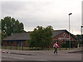
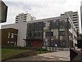
PDSA Pet Aid Hospital, Abbey Wood
On Eynsham Drive.
Image: © David Anstiss
Taken: 21 Aug 2011
0.08 miles
8
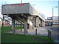
Thamesmead: A2041 Harrow Manorway footbridge
The footbridge links the Abbey Wood Park area to Southmere.
Image: © Nigel Cox
Taken: 31 Jan 2007
0.15 miles
9

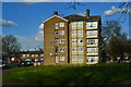
High Rise Housing, Harrow Manor Way
Image: © Des Blenkinsopp
Taken: 17 Oct 2023
0.15 miles
10
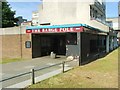
Lakeside Health Centre, Abbey Wood
On Yanton Way.
Image: © David Anstiss
Taken: 21 Aug 2011
0.17 miles