IMAGES TAKEN NEAR TO
Blithdale Road, LONDON, SE2 9QE
Introduction
This page details the photographs taken nearby to Blithdale Road, SE2 9QE by members of the Geograph project.
The Geograph project started in 2005 with the aim of publishing, organising and preserving representative images for every square kilometre of Great Britain, Ireland and the Isle of Man.

There are currently over 7.5m images from over14,400 individuals and you can help contribute to the project by visiting https://www.geograph.org.uk
Image Map
Images are licensed for reuse under creativecommons.org/licenses/by-sa/2.0
Notes
- Clicking on the map will re-center to the selected point.
- The higher the marker number, the further away the image location is from the centre of the postcode.
Image Listing (52 Images Found)
Images are licensed for reuse under creativecommons.org/licenses/by-sa/2.0
Image
Details
Distance
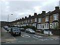
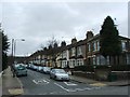
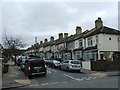
4
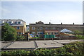
Terrace houses, Blithdale Road, Abbey Wood, London SE2
A style of housing popular between the wars. Whilst Blithdale Road is a pleasant enough road in most respects, it would appear that there are some dog owners hereabouts who would benefit from a little advice from the local Public Health department.
Image: © Dr Neil Clifton
Taken: 30 Mar 2006
0.06 miles
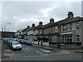
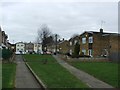
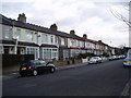
7
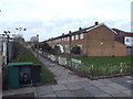
Caerleon Terrace, Abbey Wood
Housing on Caerleon Terrace in Abbey Wood, in the suburbs of south east London.
Image: © Malc McDonald
Taken: 30 Dec 2017
0.09 miles
8
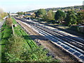
Crossrail near Abbey Wood
This is the view from the bridge carrying Eynsham Drive over the North Kent Line looking towards Abbey Wood station which is beyond the footbridge from Bostall Manorway. Some realignment of the tracks can be seen in readiness for the two new Crossrail tracks for the South-east section which will terminate at Abbey Wood. Mottisfont Road is on the left here and Lesnes Abbey Woods rises up on the horizon to the right.
For more about this section see http://www.crossrail.co.uk/route/surface/south-east-section/
Image: © Marathon
Taken: 4 Nov 2014
0.10 miles
10
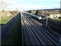
Crossrail seen from Eynsham Drive
This view is from the bridge in Eynsham Drive. The nearer two tracks are for the yet to start Elizabeth Line (also known as Crossrail). The further two tracks are for Southeastern and Thameslink trains - a Thameslink train bound for Luton is approaching. Abbey Wood station is where the bridge in the distance can be seen.
Image: © Marathon
Taken: 5 Feb 2021
0.10 miles