IMAGES TAKEN NEAR TO
Bromholm Road, LONDON, SE2 9ND
Introduction
This page details the photographs taken nearby to Bromholm Road, SE2 9ND by members of the Geograph project.
The Geograph project started in 2005 with the aim of publishing, organising and preserving representative images for every square kilometre of Great Britain, Ireland and the Isle of Man.

There are currently over 7.5m images from over14,400 individuals and you can help contribute to the project by visiting https://www.geograph.org.uk
Image Map
Images are licensed for reuse under creativecommons.org/licenses/by-sa/2.0
Notes
- Clicking on the map will re-center to the selected point.
- The higher the marker number, the further away the image location is from the centre of the postcode.
Image Listing (49 Images Found)
Images are licensed for reuse under creativecommons.org/licenses/by-sa/2.0
Image
Details
Distance
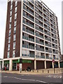
1
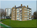
Flats, Abbey Wood
Accessed via Pynham Close, and numbered in its sequence.
Image: © Robin Webster
Taken: 14 Mar 2012
0.03 miles
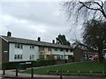
4
Eynsham Drive, Abbey Wood
A lot of the roads round here have names that sound like places, and probably are, but are not very large or famous ones.
Eynsham is a small town in Oxfordshire. I only know that because I live nearby.
Image: © Des Blenkinsopp
Taken: 17 Oct 2023
0.08 miles
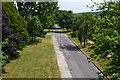
5
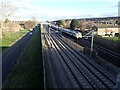
Crossrail seen from Eynsham Drive
This view is from the bridge in Eynsham Drive. The nearer two tracks are for the yet to start Elizabeth Line (also known as Crossrail). The further two tracks are for Southeastern and Thameslink trains - a Thameslink train bound for Luton is approaching. Abbey Wood station is where the bridge in the distance can be seen.
Image: © Marathon
Taken: 5 Feb 2021
0.09 miles
6
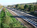
Crossrail near Abbey Wood
This is the view from the bridge carrying Eynsham Drive over the North Kent Line looking towards Abbey Wood station which is beyond the footbridge from Bostall Manorway. Some realignment of the tracks can be seen in readiness for the two new Crossrail tracks for the South-east section which will terminate at Abbey Wood. Mottisfont Road is on the left here and Lesnes Abbey Woods rises up on the horizon to the right.
For more about this section see http://www.crossrail.co.uk/route/surface/south-east-section/
Image: © Marathon
Taken: 4 Nov 2014
0.09 miles
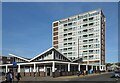
7
Abbey Wood Co-Operative Supermarket
Below a tall block of flats on Eynsham Drive.
Image: © David Anstiss
Taken: 21 Aug 2011
0.09 miles
8
Railway to Abbey Wood, Train to Plumstead
As seen from Image
This line leads from central London (via Woolwich and Plumstead) towards Abbey Wood and then onwards to Dartford.
On the left is Mottisfont Road.
Image: © David Anstiss
Taken: 21 Aug 2011
0.09 miles
9
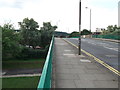
Eynsham Drive Road bridge
This road bridge leads from Abbey Wood towards Bostall Hill.
It leads over Mottisfont Road and the railway line (between Abbey Wood and Plumstead).
Image: © David Anstiss
Taken: 21 Aug 2011
0.10 miles
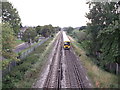
10
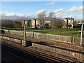
The Elizabeth Line is coming
This view is from the bridge in Eynsham Drive. The nearer two tracks are for Southeastern and Thameslink trains and the further two are for the yet to start Elizabeth Line (also known as Crossrail).
Image: © Marathon
Taken: 5 Feb 2021
0.10 miles