IMAGES TAKEN NEAR TO
Boxgrove Road, LONDON, SE2 9JJ
Introduction
This page details the photographs taken nearby to Boxgrove Road, SE2 9JJ by members of the Geograph project.
The Geograph project started in 2005 with the aim of publishing, organising and preserving representative images for every square kilometre of Great Britain, Ireland and the Isle of Man.

There are currently over 7.5m images from over14,400 individuals and you can help contribute to the project by visiting https://www.geograph.org.uk
Image Map
Images are licensed for reuse under creativecommons.org/licenses/by-sa/2.0
Notes
- Clicking on the map will re-center to the selected point.
- The higher the marker number, the further away the image location is from the centre of the postcode.
Image Listing (88 Images Found)
Images are licensed for reuse under creativecommons.org/licenses/by-sa/2.0
Image
Details
Distance
2
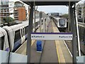
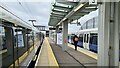
Platform view
The Elizabeth Line platforms are framed by a portal over the footbridge steps at the western end of the station.
Image: © Jonathan Wilkins
Taken: 6 Apr 2024
0.10 miles
3
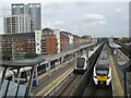
Two railways
Services on the Elizabeth Line meet Network Rail at Abbey Wood. Unit 700030 is heading for Rainham on service 9P37.
Image: © Jonathan Wilkins
Taken: 6 Apr 2024
0.11 miles
4
Journey's end, Abbey Wood
Terminus of Elizabeth Line
Image: © Chris Morgan
Taken: 26 May 2022
0.11 miles
5

Abbey Wood Elizabeth Line station
The Elizabeth Line between Paddington and Abbey Wood started operating on 24th May and this was the third day of operation. Trains wait to leave for Paddington at five minute intervals.
Image: © Marathon
Taken: 26 May 2022
0.12 miles
6
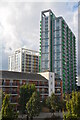
Walter Keen House and Eliza Knight apartment blocks, Abbey Wood
Walter Keen House (12 storeys) and Eliza Knight House (20 storeys) apartment blocks are near Abbey Wood station providing accommodation for London commuters. Some apartments are available through Airbnb. Abbey Wood is split between Bexley and Greenwich. This part is in Greenwich.
Image: © Rod Grealish
Taken: 23 Sep 2024
0.12 miles
7

Abbey Wood Elizabeth Line station
The Elizabeth Line between Paddington and Abbey Wood started operating on 24th May and this was the third day of operation. Trains wait to leave for Paddington at five minute intervals.
Image: © Marathon
Taken: 26 May 2022
0.12 miles
8
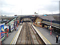
Abbey Wood station
The North Kent line through here was opened in 1849, and although there was at that time no development around here, Abbey Wood station opened at the same time, as the nearby Lesnes Abbey was seen as a tourist destination. The building of many houses in the later Victorian years, and then the large LCC Abbey Wood estate of the 1930s, ensured that Abbey Wood became an important commuter station.
Image: © Dr Neil Clifton
Taken: 24 Mar 2006
0.14 miles
9
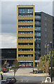
Hippersley Point apartment block, Abbey Wood, Greenwich
Hippersley Point is named for Sir John Hippersley (C17th) who salvaged building material from the nearby Lesnes Abbey before selling the abbey on in 1632. Hippersley Point is situated in Tilston Bright Square which is named for Sir Charles Tilston Bright (1832–1888) who was a British electrical engineer who oversaw the laying of the first transatlantic telegraph cable in 1858. Abbey Wood is split between the London boroughs of Bexley and Greenwich. This part of Abbey Wood is in Greenwich.
Image: © Rod Grealish
Taken: 23 Sep 2024
0.14 miles