IMAGES TAKEN NEAR TO
Panfield Road, LONDON, SE2 9DE
Introduction
This page details the photographs taken nearby to Panfield Road, SE2 9DE by members of the Geograph project.
The Geograph project started in 2005 with the aim of publishing, organising and preserving representative images for every square kilometre of Great Britain, Ireland and the Isle of Man.

There are currently over 7.5m images from over14,400 individuals and you can help contribute to the project by visiting https://www.geograph.org.uk
Image Map
Images are licensed for reuse under creativecommons.org/licenses/by-sa/2.0
Notes
- Clicking on the map will re-center to the selected point.
- The higher the marker number, the further away the image location is from the centre of the postcode.
Image Listing (34 Images Found)
Images are licensed for reuse under creativecommons.org/licenses/by-sa/2.0
Image
Details
Distance
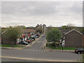
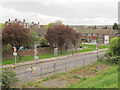
1
Abbey Wood: Panfield Road, SE2
Two of the blocks of flats on Panfield Road, viewed looking across Abbey Wood Park from Finchale Road.
Image: © Nigel Cox
Taken: 4 Oct 2007
0.06 miles
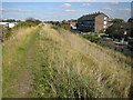
2
Littlemore Road, Abbey Wood
Seen from the Ridgeway path.
Image: © Stephen Craven
Taken: 19 Apr 2015
0.07 miles
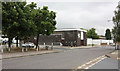
3
Sewell Road - width restriction
This road narrowing, with one direction clearly having priority over the other, is becoming quite common (at least in London) as a form of traffic calming.
Image: © Stephen Craven
Taken: 19 Apr 2015
0.10 miles
4
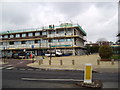
Abbey Wood Library, Eynsham Drive, London SE2
At the time of the photograph, the library and the attached parade of shops and attached flats were receiving a major refurbishment.
Image: © Dr Neil Clifton
Taken: 30 Mar 2006
0.11 miles
5
Abbey Wood: The Southern Outfall Sewer
This embankment covers the pipes of the Southern Outfall Sewer on their way to the Crossness Sewage Treatment Works. The Sewer was constructed under the direction of Joseph Bazalgette, the Chief Engineer of the Metropolitan Board of Works, and was built in the early 1860s. The embankment now has a footpath running along its top called The Ridgeway. Sewell Road is to the right. In a sad indictment of our times the powers that be feel it is necessary to monitor what is going on and the pole in the distance along the embankment is a CCTV mast. Just behind the photographer is another one.
Image: © Nigel Cox
Taken: 4 Oct 2007
0.12 miles
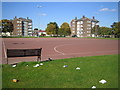
6
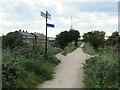
Ridgeway path, near Abbey Wood
Gentle slopes enable cyclists and people using wheelchairs to access the Ridgeway path.
Image: © Malc McDonald
Taken: 18 Sep 2021
0.12 miles
7
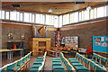
William Temple Church, Abbey Wood - Interior
Image: © John Salmon
Taken: 13 Jul 2010
0.13 miles
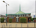
8
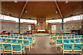
William Temple Church, Abbey Wood - East end
Image: © John Salmon
Taken: 13 Jul 2010
0.13 miles