IMAGES TAKEN NEAR TO
Monksfarm Place, Sewell Road, LONDON, SE2 9BF
Introduction
This page details the photographs taken nearby to Monksfarm Place, Sewell Road, SE2 9BF by members of the Geograph project.
The Geograph project started in 2005 with the aim of publishing, organising and preserving representative images for every square kilometre of Great Britain, Ireland and the Isle of Man.

There are currently over 7.5m images from over14,400 individuals and you can help contribute to the project by visiting https://www.geograph.org.uk
Image Map
Images are licensed for reuse under creativecommons.org/licenses/by-sa/2.0
Notes
- Clicking on the map will re-center to the selected point.
- The higher the marker number, the further away the image location is from the centre of the postcode.
Image Listing (40 Images Found)
Images are licensed for reuse under creativecommons.org/licenses/by-sa/2.0
Image
Details
Distance
1
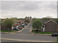
Sewell Road - width restriction
This road narrowing, with one direction clearly having priority over the other, is becoming quite common (at least in London) as a form of traffic calming.
Image: © Stephen Craven
Taken: 19 Apr 2015
0.06 miles
2
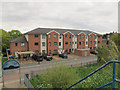
Sewell Road - new housing
This three-storey block of housing with car parking outside looks newer than most of the housing in the area. It is opposite an access point to the Ridgeway.
Image: © Stephen Craven
Taken: 19 Apr 2015
0.09 miles
4
Littlemore Road, Abbey Wood
Seen from the Ridgeway path.
Image: © Stephen Craven
Taken: 19 Apr 2015
0.11 miles
5
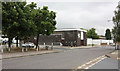
Greenwich Service Plus - Birchmere Centre
The home of Royal Greenwich Borough's vehicle fleet, they also offer MOT tests for private and commercial vehicles.
Image: © Stephen Craven
Taken: 19 Apr 2015
0.12 miles
6
Abbey Wood: Panfield Road, SE2
Two of the blocks of flats on Panfield Road, viewed looking across Abbey Wood Park from Finchale Road.
Image: © Nigel Cox
Taken: 4 Oct 2007
0.12 miles
7
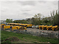
The yellow fleet of Greenwich
Parked out behind the Birchmere Centre Image are a large number of yellow council vehicles belonging to Royal Greenwich council - possibly the biggest fleet of yellow vehicles since the Vogon invasion? https://en.wikipedia.org/wiki/Vogon
Image: © Stephen Craven
Taken: 19 Apr 2015
0.12 miles
8
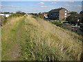
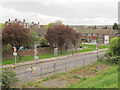
Abbey Wood: The Southern Outfall Sewer
This embankment covers the pipes of the Southern Outfall Sewer on their way to the Crossness Sewage Treatment Works. The Sewer was constructed under the direction of Joseph Bazalgette, the Chief Engineer of the Metropolitan Board of Works, and was built in the early 1860s. The embankment now has a footpath running along its top called The Ridgeway. Sewell Road is to the right. In a sad indictment of our times the powers that be feel it is necessary to monitor what is going on and the pole in the distance along the embankment is a CCTV mast. Just behind the photographer is another one.
Image: © Nigel Cox
Taken: 4 Oct 2007
0.14 miles
9
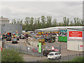
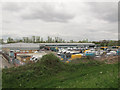
Greenwich reuse and recycling centre
Greenwich borough does better than many other councils at recycling. This is the public facility where people can bring items that don't go in the domestic recycling bin such as wood, large metal items, electrical equipment and fluorescent tubes for recycling; there are also skips for general (non-recyclable) waste. Trade vehicles have to go to the "waste recovery centre" next door Image
Image: © Stephen Craven
Taken: 19 Apr 2015
0.15 miles
10
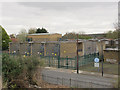
Sewell Road transformer station
Sewell Road is the main National Grid transformer station for the Plumstead / Thamesmead area.
A 2006 document http://legacy.london.gov.uk/mayor/planning/srdf/docs/east-srdf-annexes.rtf reported that by 2016 it would need to be upgraded from 4x15 MVA to 3x60 MVA transformers, the incoming supply being increased from 33kV to 132kV, to meet the increased demand from housing developments in the area. In this photo there are clearly four, not three transformers so it is not clear whether this upgrade has taken place yet.
To the right is part of the Thames Water Pumping Station. I have not been able to discover anything online about this facility, although I guess that it pumps sewage from the local area (Abbey Wood) into the Southern Outfall Sewer (the photo being taken from the Ridgeway path on top of said sewer).
Image: © Stephen Craven
Taken: 19 Apr 2015
0.15 miles