IMAGES TAKEN NEAR TO
Redbourne Drive, LONDON, SE28 8RX
Introduction
This page details the photographs taken nearby to Redbourne Drive, SE28 8RX by members of the Geograph project.
The Geograph project started in 2005 with the aim of publishing, organising and preserving representative images for every square kilometre of Great Britain, Ireland and the Isle of Man.

There are currently over 7.5m images from over14,400 individuals and you can help contribute to the project by visiting https://www.geograph.org.uk
Image Map
Images are licensed for reuse under creativecommons.org/licenses/by-sa/2.0
Notes
- Clicking on the map will re-center to the selected point.
- The higher the marker number, the further away the image location is from the centre of the postcode.
Image Listing (42 Images Found)
Images are licensed for reuse under creativecommons.org/licenses/by-sa/2.0
Image
Details
Distance
1
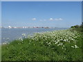
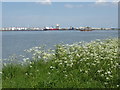
The River Thames near Cross Ness
This is just west of Cross Ness near the Thames Path. Dagenham can be seen across the River Thames. This was a very high tide on the V.E. Day Bank Holiday.
Image: © Marathon
Taken: 8 May 2020
0.03 miles
2
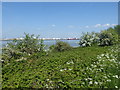
The Thames Path at Thamesmead
This is just west of Cross Ness and looks across to Dagenham.
Image: © Marathon
Taken: 8 May 2020
0.03 miles

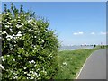
4
Thames Path at Thamesmead
A view of the Thames Path at Thamesmead, looking downstream.
The path also forms part of National Cycle Network route 1.
Image: © Malc McDonald
Taken: 19 Nov 2017
0.05 miles
5
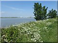
The Thames Path at Thamesmead
This is just west of Cross Ness and looks across to Dagenham.
Image: © Marathon
Taken: 8 May 2020
0.05 miles
6
The River Thames near Cross Ness
This is just west of Cross Ness near the Thames Path. Dagenham can be seen across the River Thames. This was a very high tide on the V.E. Day Bank Holiday.
Image: © Marathon
Taken: 8 May 2020
0.05 miles
7
View from the Thames Path near Cross Ness
This is just west of Cross Ness near the Thames Path. Dagenham can be seen across the River Thames. This was a very high tide on the V.E. Day Bank Holiday.
Image: © Marathon
Taken: 8 May 2020
0.05 miles
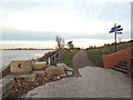
10
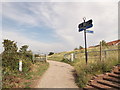
Footpath junction on the Thames Path near Southmere Lake
The Thames Path (long distance path) leads past the Crossway housing estate towards Erith. As well as the Thames Cycle Route.
It leads from a protected river wall (of the River Thames) section towards a track to Cross Ness.
Another path heads right towards the lake and nature reserve.
Image: © David Anstiss
Taken: 21 Aug 2011
0.08 miles