IMAGES TAKEN NEAR TO
St. Andrews Close, LONDON, SE28 8NY
Introduction
This page details the photographs taken nearby to St. Andrews Close, SE28 8NY by members of the Geograph project.
The Geograph project started in 2005 with the aim of publishing, organising and preserving representative images for every square kilometre of Great Britain, Ireland and the Isle of Man.

There are currently over 7.5m images from over14,400 individuals and you can help contribute to the project by visiting https://www.geograph.org.uk
Image Map
Images are licensed for reuse under creativecommons.org/licenses/by-sa/2.0
Notes
- Clicking on the map will re-center to the selected point.
- The higher the marker number, the further away the image location is from the centre of the postcode.
Image Listing (44 Images Found)
Images are licensed for reuse under creativecommons.org/licenses/by-sa/2.0
Image
Details
Distance
1
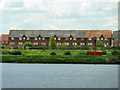
Houses, Thamesmead
At the right is Cross Ness light, on the corner between Barking Reach and Halfway Reach.
Image: © Robin Webster
Taken: 30 Jun 2011
0.02 miles
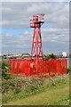
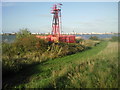
2
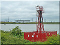
Cross Ness navigation beacon
At the corner from Barking Reach to Halfway Reach.
Image: © Robin Webster
Taken: 25 Jun 2011
0.04 miles
3
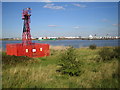
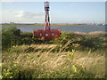
River Thames: Cross Ness lighthouse
Owned and operated by the Port of London Authority this lighthouse was at one time in an isolated location at the northern end of Plumstead Marshes. However the residential area of Thamesmead has now been built up to the river bank here, and a housing estate is behind the photographer. On the far side of the river are the tanks and the wind turbine in Dagenham Dock.
Image: © Nigel Cox
Taken: 4 Oct 2007
0.04 miles
4
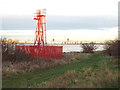
Navigation light at Cross Ness, near Thamesmead
A navigation beacon at Cross Ness, on a bend in the River Thames.
Image: © Malc McDonald
Taken: 19 Nov 2017
0.04 miles
5
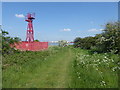
Cross Ness light
Dating from 1895, the 41 ft tower of Cross Ness Light shows a flashing white light which is visible for eight miles. The promontory on which the light stands gives its name to Crossness Sewage Treatment Works, just downriver of here. This is next to the Thames Path. Dagenham can be seen across the other side of the River Thames.
Image: © Marathon
Taken: 8 May 2020
0.04 miles
7
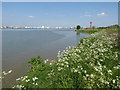
Looking to Cross Ness
This is just west of Cross Ness and the light at Cross Ness can be seen ahead. For a close up and more information on the light see https://www.geograph.org.uk/photo/2074068 Dagenham can be seen across the River Thames. This was a very high tide on the V.E. Day Bank Holiday.
Image: © Marathon
Taken: 8 May 2020
0.04 miles
8
The Thames Path at Thamesmead
This is just west of Cross Ness and the light at Cross Ness can be seen ahead. For a close up and more information on the light see https://www.geograph.org.uk/photo/2074068 Dagenham can be seen across the River Thames. This was a very high tide on the V.E. Day Bank Holiday.
Image: © Marathon
Taken: 8 May 2020
0.04 miles
9
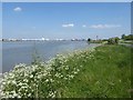
Cross Ness Light
Dating from 1895, the 41 ft tower of Cross Ness Light shows a flashing white light which is visible for eight miles. The promontory on which the light stands gives its name to Crossness Sewage Treatment Works, just downriver of here. The tower blocks on the left hand horizon are in Barking whilst the works on the right hand horizon are in Dagenham.
Image: © Marathon
Taken: 30 Aug 2010
0.04 miles
10
Cross Ness Light
Built in 1895, the 41 ft tower of Cross Ness Light shows a flashing white light which is visible for eight miles. Dagenham is seen across the Thames.
Image: © Marathon
Taken: 30 Aug 2010
0.05 miles