IMAGES TAKEN NEAR TO
Hasler Close, LONDON, SE28 8LA
Introduction
This page details the photographs taken nearby to Hasler Close, SE28 8LA by members of the Geograph project.
The Geograph project started in 2005 with the aim of publishing, organising and preserving representative images for every square kilometre of Great Britain, Ireland and the Isle of Man.

There are currently over 7.5m images from over14,400 individuals and you can help contribute to the project by visiting https://www.geograph.org.uk
Image Map
Images are licensed for reuse under creativecommons.org/licenses/by-sa/2.0
Notes
- Clicking on the map will re-center to the selected point.
- The higher the marker number, the further away the image location is from the centre of the postcode.
Image Listing (42 Images Found)
Images are licensed for reuse under creativecommons.org/licenses/by-sa/2.0
Image
Details
Distance
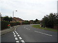
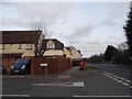
1
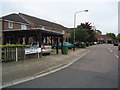
Roundabout on Thamesmead
This exceptionally large roundabout is at the junction of Carlyle Road with Crossway and Greenhaven Drive on Thamesmead. The bus is on the far side, heading along Crossway.
Image: © Marathon
Taken: 29 Mar 2021
0.07 miles
2
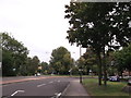
Roundabout on Central Way
The A2014 dual carriageway heads through Thamesmead North. Carlyle Road heads right towards the A2016 Eastern Way. Crossway heads straight on towards Crossway Lake and estate. Greenhaven Drive heads left towards an estate beside the River Thames.
Image: © David Anstiss
Taken: 21 Aug 2011
0.08 miles
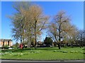
3
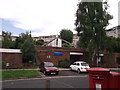
Titmus Avenue Baptist Church, Thamesmead
On Titmus Avenue.
Image: © David Anstiss
Taken: 21 Aug 2011
0.12 miles
4
Woodpecker Road, Thamesmead, London SE28
Image: © Stacey Harris
Taken: 5 Jun 2011
0.13 miles
6
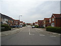
Greenhaven Drive, Thamesmead, London SE28
Image: © Stacey Harris
Taken: 5 Jun 2011
0.15 miles
7
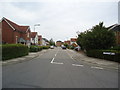
Greenhaven Drive, Thamesmead, London SE28
Image: © Stacey Harris
Taken: 5 Jun 2011
0.16 miles
8
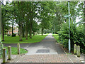
Straight path, Thamesmead
Along the line of the ancient Harrow Manorway. Manorways were frequent along the tidal Thames on both Kent and Essex sides, and still are in modified form. They were slight causeways down from higher ground and across the coastal grazing marshes to access their more remote parts.
Image: © Robin Webster
Taken: 25 Jun 2011
0.17 miles
9
Nickleby Close at the junction of Crossway, Thamesmead
There is a Dickensian theme to the roads here.
Image: © David Howard
Taken: 23 Feb 2014
0.17 miles
10
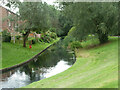
Waterway, Thamesmead
Part of an extensive drainage system which has been incorporated into linear parks.
Image: © Robin Webster
Taken: 25 Jun 2011
0.18 miles