IMAGES TAKEN NEAR TO
Crowden Way, LONDON, SE28 8HE
Introduction
This page details the photographs taken nearby to Crowden Way, SE28 8HE by members of the Geograph project.
The Geograph project started in 2005 with the aim of publishing, organising and preserving representative images for every square kilometre of Great Britain, Ireland and the Isle of Man.

There are currently over 7.5m images from over14,400 individuals and you can help contribute to the project by visiting https://www.geograph.org.uk
Image Map
Images are licensed for reuse under creativecommons.org/licenses/by-sa/2.0
Notes
- Clicking on the map will re-center to the selected point.
- The higher the marker number, the further away the image location is from the centre of the postcode.
Image Listing (40 Images Found)
Images are licensed for reuse under creativecommons.org/licenses/by-sa/2.0
Image
Details
Distance
1
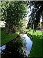
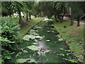
Park in Thamesmead
This is a canalised stream through a recreation ground in Thamesmead. The photograph was taken looking north.
Image: © Glyn Baker
Taken: 25 Sep 2005
0.05 miles
2
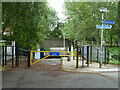
Harrow Manorway dips under Crossway, Thamesmead
Image: © Robin Webster
Taken: 25 Jun 2011
0.08 miles
3
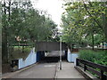
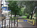
Cyclepath under Crossway
A cyclepath leads through the Crossway housing estate towards Jubilee Primary School.
Crossway above is the main circular road through the estate.
Image: © David Anstiss
Taken: 21 Aug 2011
0.08 miles
4
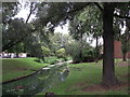
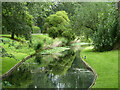
River in Crossway Estate
This green algae filled river (or drain!) winds through the estate via shallow concrete channels. But it does makes a pleasant green wildlife corridor.
Image: © David Anstiss
Taken: 21 Aug 2011
0.09 miles
5
Ducks in the Crossway River
Despite this river being green (with algae? ), various ducks live along the river/drain within the Crossway housing estate.
Image: © David Anstiss
Taken: 21 Aug 2011
0.09 miles
6
Cyclepath within Crossway Estate
A cycle path follows a river/drain within the estate towards the River Thames and the Thames Path.
Image: © David Anstiss
Taken: 21 Aug 2011
0.09 miles
7
Path, Thamesmead
Along the line of the ancient Harrow Manorway. Manorways were frequent along the tidal Thames on both Kent and Essex sides, and still are in modified form. They were slight causeways down from higher ground and across the coastal grazing marshes to access their more remote parts.
Image: © Robin Webster
Taken: 25 Jun 2011
0.10 miles
8
Waterway, Thamesmead
Part of an extensive drainage system which has been incorporated into linear parks.
Image: © Robin Webster
Taken: 25 Jun 2011
0.10 miles
10
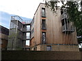
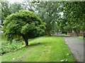
Modern housing in Crossway Estate
These two blocks of timber panelled houses, stand out among the traditional yellow and red brick houses within the estate.
At the end of Goldcrest Close.
Image: © David Anstiss
Taken: 21 Aug 2011
0.10 miles