IMAGES TAKEN NEAR TO
Oriole Way, SE28 8FE
Introduction
This page details the photographs taken nearby to Oriole Way, SE28 8FE by members of the Geograph project.
The Geograph project started in 2005 with the aim of publishing, organising and preserving representative images for every square kilometre of Great Britain, Ireland and the Isle of Man.

There are currently over 7.5m images from over14,400 individuals and you can help contribute to the project by visiting https://www.geograph.org.uk
Image Map
Images are licensed for reuse under creativecommons.org/licenses/by-sa/2.0
Notes
- Clicking on the map will re-center to the selected point.
- The higher the marker number, the further away the image location is from the centre of the postcode.
Image Listing (48 Images Found)
Images are licensed for reuse under creativecommons.org/licenses/by-sa/2.0
Image
Details
Distance
1
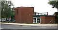
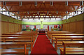
St Paul's Ecumenical Centre, Thamesmead
Image: © John Salmon
Taken: 13 Jul 2010
0.04 miles
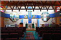
2
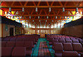
St Paul's Ecumenical Centre, Thamesmead - West end
This is the Church of England chapel
Image: © John Salmon
Taken: 13 Jul 2010
0.04 miles
3
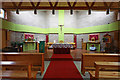
St Paul's Ecumenical Centre, Thamesmead - East end
This is the Roman Catholic chapel
Image: © John Salmon
Taken: 13 Jul 2010
0.05 miles
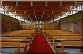
4
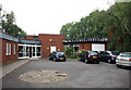
St Paul's Ecumenical Centre, Thamesmead
Image: © John Salmon
Taken: 13 Jul 2010
0.05 miles
5
St Paul's Ecumenical Centre, Thamesmead - East end
This is the Roman Catholic chapel
Image: © John Salmon
Taken: 13 Jul 2010
0.05 miles
6
St Paul's Ecumenical Centre, Thamesmead - East end
This is the Church of England chapel
Image: © John Salmon
Taken: 13 Jul 2010
0.06 miles
7
St Paul's Ecumenical Centre, Thamesmead - West end
This is the Roman Catholic chapel
Image: © John Salmon
Taken: 13 Jul 2010
0.06 miles
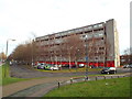
8
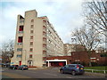
Brutalist architecture in Thamesmead
One of many blocks of flats in Thamesmead built from concrete.
Image: © Malc McDonald
Taken: 30 Dec 2017
0.08 miles
9
Flats on Saunders Way, Thamesmead
Brutalist architecture in Thamesmead.
Image: © Malc McDonald
Taken: 30 Dec 2017
0.10 miles
10

Tump 53, Thamesmead
Apart from being built on former marshland, with many of the former drainage dykes being landscaped as seen here, most of the area was also part of the Royal Arsenal at Woolwich. The remote marshes were ideal for testing explosives and to do this a series of brick enclosures called tumps were constructed. Any explosion occurring would then be directed upwards. Some of the tumps have survived to become part of the landscape as here - the outer brick wall can just be made out on the right. This tump, known as Tump 53, has been a nature reserve run by the London Wildlife Trust for many years.
Image: © Marathon
Taken: 8 Mar 2011
0.11 miles