IMAGES TAKEN NEAR TO
Kingfisher Close, LONDON, SE28 8ES
Introduction
This page details the photographs taken nearby to Kingfisher Close, SE28 8ES by members of the Geograph project.
The Geograph project started in 2005 with the aim of publishing, organising and preserving representative images for every square kilometre of Great Britain, Ireland and the Isle of Man.

There are currently over 7.5m images from over14,400 individuals and you can help contribute to the project by visiting https://www.geograph.org.uk
Image Map
Images are licensed for reuse under creativecommons.org/licenses/by-sa/2.0
Notes
- Clicking on the map will re-center to the selected point.
- The higher the marker number, the further away the image location is from the centre of the postcode.
Image Listing (53 Images Found)
Images are licensed for reuse under creativecommons.org/licenses/by-sa/2.0
Image
Details
Distance
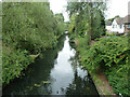
1
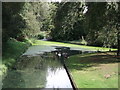
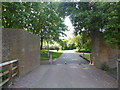
River junction in Crossways Housing Estate
As seen from Image
This river/drain flows through housing estate. It is popular with local wildlife, including ducks, swans and geese.
Image: © David Anstiss
Taken: 21 Aug 2011
0.04 miles
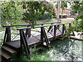
2
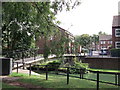
Footbridge on Green Chain Walk (2)
This footbridge leads between Kingfisher Close and Fieldfare Road (in the background), is used by the long distance path leading through the Crossway housing estate from the River Thames towards Southmere, Thamesmead.
It crosses over an algae filled drain/river within the estate
Image: © David Anstiss
Taken: 21 Aug 2011
0.05 miles
3
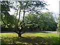
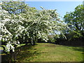
Inside a tump on Thamesmead
A substantial amount of the land at Thamesmead once formed part of the Royal Arsenal where explosives and weapons were manufactured, tested and stored. About 30 moated magazines, known as tumps, were built around 1890 to direct any accidental explosion harmlessly upwards. Some of the tumps have been preserved within Thamesmead. The brick walls, banked with earth have been preserved but the special lightweight roofs have been removed. After the First World War the Arsenal declined because it lay too far from coal and steel sources and the site was vulnerable to air attacks. The GLC was able to purchase the land from the Ministry of Defence in 1965 to build Thamesmead on the site.
This tump is on the Green Chain Walk near Fieldfare Road and is now a park. The old wall can just be seen beyond the tree. See also https://www.geograph.org.uk/photo/6455551 which shows another tump on Thamesmead which is now a nature reserve.
Image: © Marathon
Taken: 24 Apr 2020
0.05 miles
4
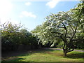
Blossom inside a tump on Thamesmead
A substantial amount of the land at Thamesmead once formed part of the Royal Arsenal where explosives and weapons were manufactured, tested and stored. About 30 moated magazines, known as tumps, were built around 1890 to direct any accidental explosion harmlessly upwards. Some of the tumps have been preserved within Thamesmead. The brick walls, banked with earth have been preserved but the special lightweight roofs have been removed. After the First World War the Arsenal declined because it lay too far from coal and steel sources and the site was vulnerable to air attacks. The GLC was able to purchase the land from the Ministry of Defence in 1965 to build Thamesmead on the site.
This tump is on the Green Chain Walk near Fieldfare Road and is now a park. The old wall can just be seen on the left. See also https://www.geograph.org.uk/photo/6455551 which shows another tump on Thamesmead which is now a nature reserve.
Image: © Marathon
Taken: 24 Apr 2020
0.05 miles
5
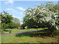
Entering a tump on the Green Chain Walk
A substantial amount of the land at Thamesmead once formed part of the Royal Arsenal where explosives and weapons were manufactured, tested and stored. About 30 moated magazines, known as tumps, were built around 1890 to direct any accidental explosion harmlessly upwards. Some of the tumps have been preserved within Thamesmead. The brick walls, banked with earth have been preserved but the special lightweight roofs have been removed. After the First World War the Arsenal declined because it lay too far from coal and steel sources and the site was vulnerable to air attacks. The GLC was able to purchase the land from the Ministry of Defence in 1965 to build Thamesmead on the site.
This tump is on the Green Chain Walk near Fieldfare Road and is now a park. The old walls can be seen on either side of the entrance and some idea of the size looking across to the far wall. See also https://www.geograph.org.uk/photo/6455551 which shows another tump on Thamesmead which is now a nature reserve.
Image: © Marathon
Taken: 24 Apr 2020
0.07 miles
6
Blossom inside a tump on Thamesmead
A substantial amount of the land at Thamesmead once formed part of the Royal Arsenal where explosives and weapons were manufactured, tested and stored. About 30 moated magazines, known as tumps, were built around 1890 to direct any accidental explosion harmlessly upwards. Some of the tumps have been preserved within Thamesmead. The brick walls, banked with earth have been preserved but the special lightweight roofs have been removed. After the First World War the Arsenal declined because it lay too far from coal and steel sources and the site was vulnerable to air attacks. The GLC was able to purchase the land from the Ministry of Defence in 1965 to build Thamesmead on the site.
This tump is on the Green Chain Walk near Fieldfare Road and is now a park. See also https://www.geograph.org.uk/photo/6455551 which shows another tump on Thamesmead which is now a nature reserve.
Image: © Marathon
Taken: 24 Apr 2020
0.08 miles
7
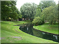
Waterway, Thamesmead
Part of an extensive drainage system which has been incorporated into linear parks.
Image: © Robin Webster
Taken: 25 Jun 2011
0.08 miles
8
Inside a tump on Thamesmead
A substantial amount of the land at Thamesmead once formed part of the Royal Arsenal where explosives and weapons were manufactured, tested and stored. About 30 moated magazines, known as tumps, were built around 1890 to direct any accidental explosion harmlessly upwards. Some of the tumps have been preserved within Thamesmead. The brick walls, banked with earth have been preserved but the special lightweight roofs have been removed. After the First World War the Arsenal declined because it lay too far from coal and steel sources and the site was vulnerable to air attacks. The GLC was able to purchase the land from the Ministry of Defence in 1965 to build Thamesmead on the site.
This tump is on the Green Chain Walk near Fieldfare Road and is now a park. See also https://www.geograph.org.uk/photo/6455551 which shows another tump on Thamesmead which is now a nature reserve.
Image: © Marathon
Taken: 24 Apr 2020
0.08 miles
9
Waterway, Thamesmead
Part of an extensive drainage system, much of which has been incorporated into linear parks.
Image: © Robin Webster
Taken: 25 Jun 2011
0.08 miles
10
Footbridge on Green Chain Walk
This footbridge leads between Curlew Close, and openspace area and Fieldfare Road, is used by the long distance path leading through the Crossway housing estate towards the River Thames.
It crosses over an algae filled drain/river within the estate.
Image: © David Anstiss
Taken: 21 Aug 2011
0.08 miles