IMAGES TAKEN NEAR TO
Tideslea Path, LONDON, SE28 0LZ
Introduction
This page details the photographs taken nearby to Tideslea Path, SE28 0LZ by members of the Geograph project.
The Geograph project started in 2005 with the aim of publishing, organising and preserving representative images for every square kilometre of Great Britain, Ireland and the Isle of Man.

There are currently over 7.5m images from over14,400 individuals and you can help contribute to the project by visiting https://www.geograph.org.uk
Image Map
Images are licensed for reuse under creativecommons.org/licenses/by-sa/2.0
Notes
- Clicking on the map will re-center to the selected point.
- The higher the marker number, the further away the image location is from the centre of the postcode.
Image Listing (97 Images Found)
Images are licensed for reuse under creativecommons.org/licenses/by-sa/2.0
Image
Details
Distance
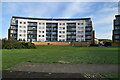
1
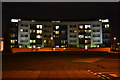
Night view of flats at Thamesmead West
Image: © David Martin
Taken: 10 Oct 2014
0.01 miles
7
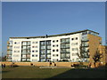
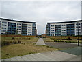
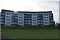
Apartments by the river, Thamesmead
A new apartment block in Thamesmead, South East London. These apartments have a view out over the River Thames.
Thamesmead is a new town developed since the 1960s, on reclaimed marshland south of the Thames.
Image: © Malc McDonald
Taken: 22 Oct 2011
0.05 miles
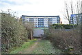
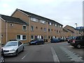
9
Merbury Close, Thamesmead, London SE28
Image: © Stacey Harris
Taken: 5 Jun 2011
0.05 miles