IMAGES TAKEN NEAR TO
Marathon Way, LONDON, SE28 0JJ
Introduction
This page details the photographs taken nearby to Marathon Way, SE28 0JJ by members of the Geograph project.
The Geograph project started in 2005 with the aim of publishing, organising and preserving representative images for every square kilometre of Great Britain, Ireland and the Isle of Man.

There are currently over 7.5m images from over14,400 individuals and you can help contribute to the project by visiting https://www.geograph.org.uk
Image Map
Images are licensed for reuse under creativecommons.org/licenses/by-sa/2.0
Notes
- Clicking on the map will re-center to the selected point.
- The higher the marker number, the further away the image location is from the centre of the postcode.
Image Listing (22 Images Found)
Images are licensed for reuse under creativecommons.org/licenses/by-sa/2.0
Image
Details
Distance
2

Discovery Primary School, Thamesmead
On Battery Road, within Thamesmead Ecopark.
Image: © David Anstiss
Taken: 21 Aug 2011
0.09 miles
3
Leading towards the future !
Barnham Drive leads off Battery Road towards one house. At the moment.
It leads from the Gallions Reach Urban Village (ecopark) towards another area of development land on the former Royal Arsenal,Woolwich
The final phase is the creation of Gallions Reach Park (a 14.3 acre, public open space land, between Gallions Hill and the River Thames).
Image: © David Anstiss
Taken: 21 Aug 2011
0.12 miles
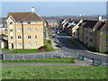
4
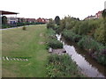
Foxglove path, West Thamesmead
This stream-side path leads from Battery Road, through Gallions Reach Urban Village (eco-park) towards a small lake.
See Image
On the left is the back of the Discovery Primary School.
Image: © David Anstiss
Taken: 21 Aug 2011
0.13 miles
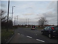
5
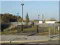
Cycle route to nowhere, Thamesmead
It's a cycle route, but where does it lead? The fence a few metres away blocks the way.
Image: © Malc McDonald
Taken: 22 Oct 2011
0.13 miles
6
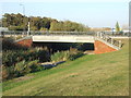
Canal bridge, Thamesmead
A bridge carrying a road over a canal in Thamesmead, South East London.
Image: © Malc McDonald
Taken: 22 Oct 2011
0.14 miles
7
Iron Mountain, Thamesmead
A view from the Thamesmead Tor (alias Gallions Hill) of a pair of huge warehouses housing Iron Mountain document storage. See also Image
Image: © Stephen Craven
Taken: 21 Apr 2014
0.15 miles
9

Iron Mountain, Thamesmead
A pair of huge warehouses on the White Hart Triangle industrial estate. Iron Mountain provides document storage.
Image: © Stephen Craven
Taken: 9 Jun 2012
0.19 miles
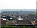
10
Hill View Drive seen from Gallions Hill
Gallions Hill is a sixty feet high landmark created from "recycled excavated material". A spiral path leads to the summit which provides widespread views up and down the Thames. To the south the views are only as far as the ridge between Shooters Hill, Plumstead Common, Bostall Heath and Lesnes Abbey Woods.
Image: © Marathon
Taken: 20 Mar 2015
0.19 miles